Dyer, IN | |||||||||||||||||
|---|---|---|---|---|---|---|---|---|---|---|---|---|---|---|---|---|---|
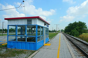
 The old Amtrak shelter station at Dyer before replacement, looking "railroad west" (compass northwest) towards Chicago. | |||||||||||||||||
| General information | |||||||||||||||||
| Location | 913 Sheffield Avenue Dyer, Indiana United States | ||||||||||||||||
| Coordinates | 41°30′55″N 87°31′05″W / 41.5154°N 87.5181°W | ||||||||||||||||
| Line(s) | CSX Monon Subdivision | ||||||||||||||||
| Platforms | 1 side platform | ||||||||||||||||
| Tracks | 1 | ||||||||||||||||
| Construction | |||||||||||||||||
| Accessible | Yes | ||||||||||||||||
| Other information | |||||||||||||||||
| Station code | Amtrak: DYE | ||||||||||||||||
| History | |||||||||||||||||
| Rebuilt | 1986, 2014 | ||||||||||||||||
| Passengers | |||||||||||||||||
| FY 2023 | 989[1] (Amtrak) | ||||||||||||||||
| Services | |||||||||||||||||
| |||||||||||||||||
| |||||||||||||||||
| |||||||||||||||||
Dyer station is an Amtrak station in Dyer, Indiana, served by the Cardinal route.
Dyer Station was merely a little shelter with seats before a renovation in 2014, which demolished the "Amshack" shelter built in 1986 and constructed a larger station house which was accessible, and repaved the platform and parking lot.[2] It is located north of an at-grade crossing of two railroad lines; CSX (formerly the Monon Railroad) and the Elgin, Joliet & Eastern.[3] The original depot stood at the diamond junction itself.[4]
- ^ "Amtrak Fact Sheet, Fiscal Year 2023: State of Indiana" (PDF). Amtrak. March 2024. Retrieved June 27, 2024.
- ^ "Dyer, IN (DYE) – Great American Stations". Retrieved 2021-07-10.
- ^ Crossing CSX and EJ&E; August 28, 2001 (TrainWeb)
- ^ Longest (2007), 93.

