Back Edogawa, Tokyo ACE إيدوغاوا (طوكيو) Arabic Edoqava AZ Edogawa Catalan Эдогава (махсус район) CE Edogawa-ku CEB Edogawa Danish Edogawa German Kvartalo Edogaŭa EO Edogawa (Tokio) Spanish
This article needs additional citations for verification. (August 2018) |
Edogawa
江戸川区 | |
|---|---|
| Edogawa City[1] | |
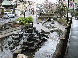
 Furukawa Waterside Park in Edogawa | |
 Location of Edogawa in Tokyo Metropolis | |
| Coordinates: 35°42′N 139°53′E / 35.700°N 139.883°E | |
| Country | Japan |
| Region | Kantō |
| Prefecture | Tokyo Metropolis |
| First official recorded | 721 AD |
| As City of Tokyo | October 1, 1932 |
| As Special ward of Tokyo | July 1, 1943 |
| Government | |
| • Mayor | Takeshi Saitō (since April 2019) |
| Area | |
• Total | 49.90 km2 (19.27 sq mi) |
| Population (October 1, 2020[2]) | |
• Total | 697,932 |
| • Density | 13,986/km2 (36,220/sq mi) |
| Ethnic groups | |
| Time zone | UTC+09:00 (JST) |
| Climate | Cfa |
| Website | www |
| Symbols | |
| Flower | Rhododendron |
| Tree | Cinnamonum camphora |

Edogawa (江戸川区, Edogawa-ku) is a special ward in the Tokyo Metropolis in Japan. It takes its name from the Edo River that runs from north to south along the eastern edge of the ward. In English, it uses the name Edogawa City.
The easternmost of the wards, it shares boundaries with the cities of Urayasu and Ichikawa in Chiba Prefecture (to the east) and with the wards of Katsushika (to the north), Sumida and Kōtō (to the west). It meets the city of Matsudo in Chiba at a point.
Edogawa has a sister-city relationship with Gosford, New South Wales, Australia. Domestically, it has friendship ties with the cities of Azumino in Nagano Prefecture and Tsuruoka in Yamagata Prefecture.
As of January 1, 2020, the ward has an estimated population of 695,797, and a population density of 13,925 persons per km2. [citation needed] The total area is 49.90 km2.
- ^ Multilingual 江戸川区公式ホームページ. City.edogawa.tokyo.jp. Archived from the original on November 19, 2017. Retrieved August 1, 2018.
- ^ "Population by District". Tokyo Statistical Yearbook. Retrieved July 15, 2022.


