Back Enz ALS نهر انز (نهر) ARZ Enz (suba sa Alemanya, Baden-Württemberg Region) CEB Энц (Неккар юппи) CV Enz Danish Enz German Enz EO Enz Spanish انتس FA Enz French
| Enz | |
|---|---|
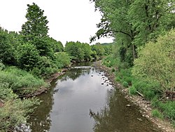
 The Enz in the nature reserve between Niefern and Mühlacker | |
 | |
| Location | |
| Country | Germany |
| State | Baden-Württemberg |
| Physical characteristics | |
| Source | |
| • location | source of the Poppelbach in Besenfeld |
| • coordinates | 48°36′33″N 8°27′01″E / 48.609028°N 8.450278°E |
| Mouth | |
• location | Neckar in Besigheim |
• coordinates | 49°0′20″N 9°8′52″E / 49.00556°N 9.14778°E |
• elevation | 170 m (560 ft) |
| Length | 105.6 km (65.6 mi) (including Poppelbach) [1] |
| Basin size | 2,229 km2 (861 sq mi)[2] [1] |
| Basin features | |
| Progression | Neckar→ Rhine→ North Sea |
| Tributaries | |
| • left | Rombach, Eyach, Schmiebach, Metter |
| • right | Little Enz, Nagold, Strudelbach, Glems, Leudelsbach |
The Enz is a river flowing north from the Black Forest to the Neckar in Baden-Württemberg. It is 106 km long.
Its headstreams – the Little Enz (German: Kleine Enz) and the Great Enz or Big Enz (Große Enz) – rise in the Northern Black Forest, the latter at Enzklösterle. In Calmbach, the Little Enz and the Big Enz join to form the Enz. The river passes through Neuenbürg and Pforzheim, where it leaves the Black Forest. It then flows through the cities of Vaihingen and Bietigheim-Bissingen. Along the lower course, wine is grown.
Major tributaries to the Enz are Glems and Nagold (with its tributary Würm). Near Besigheim, the Enz feeds into the Neckar.
In earlier times, the Enz was important for the timber rafting industry.