Back Área metropolitana de Evansville Spanish ایوانز ویل، انڈیانا-کینٹکی میٹروپولیٹن شماریاتی علاقہ UR
This article's factual accuracy may be compromised due to out-of-date information. The reason given is: It was now divided into the Evansville, IN metropolitan statistical area and the Henderson, KY micropolitan statistical area, which together make up a combined statistical area. (September 2024) |
This article needs additional citations for verification. (October 2021) |
Evansville Metro, Tri-state area | |
|---|---|
| Evansville–Henderson, IN–KY, Combined Statistical Area | |
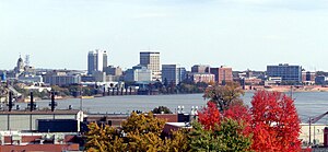
 Downtown Evansville skyline from Dreier Boulevard | |
 | |
| Country | |
| State | |
| Largest city | Evansville, Indiana |
| Other cities | – Boonville, IN – Henderson, KY – Newburgh, IN – Princeton, IN – Mount Vernon, IN |
| Area | |
• Total | 2,367 sq mi (6,130 km2) |
| Highest elevation | 595 ft (181 m) |
| Lowest elevation | 320 ft (98 m) |
| Population | |
• Total | 358,676 |
| • Rank | 160th in the U.S. |
| • Density | 152.9/sq mi (59.0/km2) |
| GDP | |
| • Total | $25.278 billion (2022) |
| Time zone | UTC−6 (CST) |
| • Summer (DST) | UTC−5 (CDT) |
The Evansville metropolitan area is the 164th largest metropolitan statistical area (MSA) in the United States. The primary city is Evansville, Indiana, the third most populous city in Indiana and the most populous city in Southern Indiana as well as the hub for Southwestern Indiana. Other Indiana cities include Boonville, Mount Vernon, Jasper, Oakland City, Princeton, and Vincennes. Large towns in Indiana include Chandler, Fort Branch, McCutchanville, and Newburgh. Cities in Kentucky include Henderson, Dixon, Providence, and Robards and currently covers an area of 2,367 sq mi (6,130 km2). It is the primary metropolitan area in the Illinois–Indiana–Kentucky Tri-State Area.