Back ፌርፋክስ ካውንቲ AM Fægerfæxsċīr ANG مقاطعة فيرفاكس (فيرجينيا) Arabic Fairfax County, Virginia BAR Феърфакс (окръг, Вирджиния) Bulgarian ফেয়ারফ্যাক্স কাউন্টি, ভার্জিনিয়া BPY Fairfax Gông (Virginia) CDO Фэрфакс (гуо, Виргини) CE Fairfax County CEB Fairfax County Czech
Fairfax County | |
|---|---|
Mount Vernon plantation | |
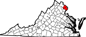
 Location within the U.S. state of Virginia | |
 Virginia's location within the U.S. | |
| Coordinates: 38°50′N 77°17′W / 38.83°N 77.28°W | |
| Country | |
| State | |
| Founded | June 19, 1742 |
| Named for | Thomas Fairfax, 6th Lord Fairfax of Cameron |
| Seat | Fairfax (independent city)1 |
| Largest town | Herndon |
| Area | |
• Total | 406 sq mi (1,050 km2) |
| • Land | 391.02 sq mi (1,012.7 km2) |
| • Water | 15.47 sq mi (40.1 km2) 3.8% |
| Population (2020) | |
• Total | 1,150,309 |
| • Density | 2,941.82/sq mi (1,135.84/km2) |
| Time zone | UTC−5 (Eastern) |
| • Summer (DST) | UTC−4 (EDT) |
| ZIP Codes | 20120, 20121, 20122, 20124, 20151, 20152, 20153, 20164, 20166, 20170, 20171, 20172, 20190, 20191, 20192, 20194, 20195, 20196, 22003, 22009, 22015, 22018, 22019, 22027, 22030, 22031, 22032, 22033, 22035, 22037, 22038, 22039, 22041, 22042, 22043, 22044, 22046, 22060, 22066, 22067, 22079, 22081, 22082, 22101, 22102, 22106, 22116, 22121, 22124, 22150, 22151, 22152, 22153, 22158, 22159, 22160, 22161, 22180, 22181, 22182, 22183, 22185, 22199, 22203, 22204, 22205, 22206, 22207, 22213, 22302, 22303, 22304, 22306, 22307, 22308, 22309, 22310, 22311, 22312, 22315 |
| Area code | 703, 571 |
| Congressional districts | 8th, 10th, 11th |
| Website | fairfaxcounty.gov |
| 1 Administrative and court offices are located in unincorporated areas in Fairfax County | |
Fairfax County, officially the County of Fairfax, is a county in the Commonwealth of Virginia. With a population of 1,150,309 as of the 2020 census,[1] it is the most populous county in Virginia, the most populous jurisdiction in the Washington metropolitan area, and the most populous location in the Washington–Baltimore combined statistical area. The county seat is Fairfax; however, because it is an independent city under Virginia law, the city of Fairfax is not part of the county.[2]
The county is part of the Northern Virginia region and forms part of the suburban ring of Washington, D.C., the nation's capital. The county is predominantly suburban with some urban and rural pockets. It borders Montgomery County, Maryland to its north, Falls Church, Alexandria, Arlington County, and Prince George's County, Maryland to its east, Charles County, Maryland to its southeast, Prince William County to its southwest, and Loudoun County to its northwest.
The county is home to the offices of the director of national intelligence in McLean and the headquarters of four U.S. intelligence agencies: the Central Intelligence Agency at the George Bush Center for Intelligence in Langley, the National Geospatial-Intelligence Agency in Springfield, the National Reconnaissance Office in Chantilly, and the National Counterterrorism Center in McLean.
In academia, the county is home to the flagship campus of George Mason University in Fairfax, CIA University in Chantilly, Sherman Kent School for Intelligence Analysis in Reston, and several Northern Virginia Community College campuses. In the private sector, ten of the Fortune 500 companies are headquartered in the county as of 2023.[3]
As of 2020, Fairfax County's median household income of $127,866 is the fifth-highest in the nation.
- ^ "U.S. Census Bureau QuickFacts: Fairfax County, Virginia". United States Census Bureau. Retrieved November 7, 2021.
- ^ "Find a County". National Association of Counties. Retrieved September 15, 2019.
- ^ Reed, Sharon (June 8, 2023). "June 8, 2023: 10 Fairfax County-based firms rank on 2023 Fortune 500 List + Weekly Business News Digest". Fairfax County EDA. Retrieved May 8, 2024.


