| Faulconbridge Blue Mountains, New South Wales | |||||||||||||||
|---|---|---|---|---|---|---|---|---|---|---|---|---|---|---|---|
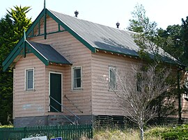
 Former chapel in Carpenter Gothic style, Great Western Highway | |||||||||||||||
 | |||||||||||||||
| Coordinates | 33°41′40″S 150°32′12″E / 33.694396°S 150.536767°E | ||||||||||||||
| Population | 4,025 (2016 census)[1] | ||||||||||||||
| Postcode(s) | 2776 | ||||||||||||||
| Elevation | 450 m (1,476 ft) | ||||||||||||||
| Location |
| ||||||||||||||
| LGA(s) | City of Blue Mountains | ||||||||||||||
| State electorate(s) | Blue Mountains | ||||||||||||||
| Federal division(s) | Macquarie | ||||||||||||||
| |||||||||||||||
Faulconbridge is a village located in the Blue Mountains 77 km west of the Sydney central business district, New South Wales and is 450 metres above sea level. At the 2016 census, Faulconbridge had a population of 4,025 people.[1] At the 2021 cenus, the population had risen to 4,156.[2]
- ^ a b Australian Bureau of Statistics (27 June 2017). "Faulconbridge (State Suburb)". 2016 Census QuickStats. Retrieved 24 April 2018.
- ^ "2021 Faulconbridge, Census Community Profiles | Australian Bureau of Statistics". www.abs.gov.au. Retrieved 18 October 2024.

