Field | |
|---|---|
Unincorporated | |
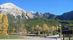
 Front entrance to the townsite | |
| Coordinates: 51°23′45″N 116°29′20″W / 51.39583°N 116.48889°W | |
| Country | Canada |
| Province | British Columbia |
| Regional district | Columbia-Shuswap |
| Named for | Cyrus West Field |
| Population (2011)[1] | |
• Total | 195 |
| Time zone | UTC−7 (Mountain Standard Time (MST)) |
| • Summer (DST) | UTC−6 (MDT) |
| Postal code | V0A 1G0 |


Field is an unincorporated community of approximately 169 people located in the Kicking Horse River valley of southeastern British Columbia, Canada, within the confines of Yoho National Park. At an elevation of 1,256 m (4,121 ft), it is 27 km (17 mi) west of Lake Louise along the Trans-Canada Highway, which provides the only road access to the town. The community is named for Cyrus West Field of Transatlantic telegraph cable fame, who visited the area in 1884.[2]: 81
- ^ Cite error: The named reference
2011censuswas invoked but never defined (see the help page). - ^ Akrigg, G.P.V.; Akrigg, Helen B. (1986), British Columbia Place Names (3rd, 1997 ed.), Vancouver: UBC Press, ISBN 0-7748-0636-2

