Back خور كلايد Arabic Ферт-оф-Клайд BE Фърт ъф Клайд Bulgarian Linne Chluaidh BR Fiord de Clyde Catalan Firth of Clyde CEB Firth of Clyde Czech Moryd Clud CY Firth of Clyde Danish Firth of Clyde German
| Firth of Clyde | |
|---|---|
| Clyde Waters, Clyde Sea | |
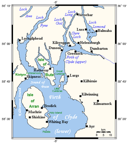
 Map of the Firth of Clyde. | |
| Location | Scotland, United Kingdom |
| Coordinates | 55°40′N 5°00′W / 55.667°N 5.000°Wgrid reference NS153652 |
| Type | Firth |
| Etymology | Scottish |
| Part of | Irish Sea |
| River sources | River Clyde |
| Basin countries | Scotland |
| Surface area | 4,279 cubic kilometres (1,027 cu mi) |
| Average depth | 58 metres (190 ft) |
| Max. depth | 198 metres (650 ft) |
| Shore length1 | 1,256 kilometres (780 mi) |
| Surface elevation | 0 metres (0 ft) |
| Frozen | No |
| Islands | Isle of Arran, Isle of Bute, Isle of Cumbrae |
| References | [1][2] |
| Designated | 5 September 2000 |
| Reference no. | 1036[3] |
Invalid designation | |
| Designated | 2008 |
Invalid designation | |
| Designated | 7 August 2014 |
| Reference no. | 10414[7][8] |
| 1 Shore length is not a well-defined measure. | |
The Firth of Clyde, is the estuary of the River Clyde, on the west coast of Scotland. The Firth has some of the deepest coastal waters of the British Isles. The Firth is sheltered from the Atlantic Ocean by the Kintyre Peninsula. The Firth lies between West Dunbartonshire in the north, Argyll and Bute in the west and Inverclyde, North Ayrshire and South Ayrshire in the east. The Kilbrannan Sound is a large arm of the Firth, separating the Kintyre Peninsula from the Isle of Arran. The Kyles of Bute separates the Isle of Bute from the Cowal Peninsula. The Sound of Bute separates the islands of Bute and Arran.
The Highland Boundary Fault crosses the Firth. The Firth also played a vital military role during World War II.
The Firth is sometimes called the Clyde Waters or Clyde Sea, and is customarily considered to be part of the Irish Sea.[9][10]
- ^ "multiple"
- ^ "Facts and figures about Scotland's sea area (coastline length, sea area in sq kms)". marine.gov.scot.
- ^ "Inner Clyde Estuary | Ramsar Sites Information Service". rsis.ramsar.org.
- ^ "No Take Zone". 22 June 2018.
- ^ "The establishment of the 1st Community Managed Marine Protected Area in the Isle of Arran, Scotland".
- ^ "SiteLink". sitelink.nature.scot.
- ^ "SiteLink".
- ^ "NRS Web Continuity Service" (PDF).
- ^ "3. THE ENVIRONMENT OF THE CLYDE SEA". www.gov.scot. 7 May 2021.
- ^ C.Michael Hogan. 2011. Irish Sea. eds. P.Saundry & C.Cleveland. Encyclopedia of Earth. National council for Science and the Environment. Washington DC Archived 2 June 2013 at the Wayback Machine

