Back Firth of Thames (luuk, lat -37,00, long 175,42) CEB Firth of Thames German Estuario de Thames Spanish Firth of Thames French Firth of Thames Italian Темски Ферт MK Firth of Thames NN Firth of Thames NB
| Firth of Thames | |
|---|---|
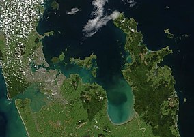
 An image showing the Hauraki Gulf. The Firth of Thames is the large bay to the southeast. | |
 | |
| Location | North Island of New Zealand |
| Area | 8,927 hectares (22,060 acres) |
| Designated | 29 January 1990 |
| Reference no. | 459[1] |
The Firth of Thames (Māori: Tikapa Moana-o-Hauraki) is a large bay located in the north of the North Island of New Zealand. It is the firth of the rivers Waihou and Piako, the former of which was formerly named the Thames River, and the town of Thames lies on its southeastern coast.
Its Maori name is Tikapa. In traditional legend, the firth and the greater Hauraki Gulf are protected by a taniwha named Ureia, who takes the form of a whale.[2]
The firth lies at the southern end of the Hauraki Gulf, southeast of the city of Auckland. It occupies a rift valley or graben between the Coromandel Peninsula and Hunua Ranges, which continues into the Hauraki Plains to the south.
- ^ "Firth of Thames". Ramsar Sites Information Service. Retrieved 25 April 2018.
- ^ Wilson, Karen (28 August 2018). "Brief of Evidence of Karen Akamira Wilson on Behalf of Te Ākitai Waiohua" (PDF). Ministry of Justice. Archived from the original (PDF) on 27 January 2019. Retrieved 17 May 2022.