Back Флинт Хилс Bulgarian Flint Hills (kabukiran sa Tinipong Bansa, Kansas) CEB Flint Hills German Prairies d'herbes hautes des Flint Hills French Flint Hills Italian Flint Hills Portuguese Flint Hills SIMPLE Флінт-Гіллс Ukrainian
| Flint Hills | |
|---|---|
 | |
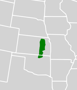
 Map of the Flint Hills ecoregion | |
| Location | Manhattan, Kansas (largest), Great Plains, United States |
| Coordinates | 37°17′00″N 96°40′31″W / 37.28333°N 96.67528°W |
| Length | 157 mi (253 km) |
| Width | 93 mi (150 km) |
| Area | 9,936 sq mi (25,730 km2) |
| Elevation | 1,680 ft (512 m) |
| Website | Flint Hills Website |
The Flint Hills, historically known as Bluestem Pastures or Blue Stem Hills,[1] are a region of hills and prairies that lie mostly in eastern Kansas. It is named for the abundant residual flint eroded from the bedrock that lies near or at the surface. It consists of a band of hills extending from Marshall and Washington Counties in the north to Cowley County, Kansas and Kay and Osage Counties in Oklahoma in the south, to Geary and Shawnee Counties west to east.[2] Oklahomans generally refer to the same geologic formation as the Osage Hills or "the Osage."
The Flint Hills Ecoregion is designated as a distinct region because it has the densest coverage of intact tallgrass prairie in North America. Due to its rocky soil, the early settlers were unable to plow the area, resulting in the prevalence of cattle ranches as opposed to the crop land more typical of the Great Plains. These ranches rely on annual controlled burns conducted by ranchers every spring to renew the prairie grasses for cattle to graze.
The Flint Hills Discovery Center, a science and history museum focusing on the Flint Hills, opened in Manhattan, Kansas, in April 2012.
- ^ U.S. Geological Survey Geographic Names Information System: Flint Hills
- ^ Klinkenborg, Verlyn (April 2007). "Splendor of the Grass: The Prairie's Grip is Unbroken in the Flint Hills of Kansas". National Geographic. Archived from the original on February 26, 2018. Retrieved March 27, 2007.