Back فلوفيلا Arabic فلوفيلا ARZ فلوویلا، جورجیا AZB Flovilla Catalan Фловилла (Джорджи) CE Flovilla CEB Flovilla CH Flovilla, Georgia CY Flovilla Spanish Flovilla (Georgia) EU
Flovilla, Georgia | |
|---|---|
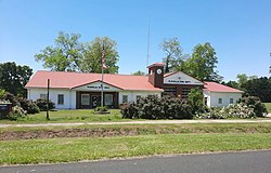
 Flovilla City Hall | |
 Location in Butts County and the state of Georgia | |
| Coordinates: 33°15′20″N 83°53′54″W / 33.25556°N 83.89833°W | |
| Country | United States |
| State | Georgia |
| County | Butts |
| Area | |
• Total | 1.96 sq mi (5.07 km2) |
| • Land | 1.96 sq mi (5.07 km2) |
| • Water | 0.00 sq mi (0.00 km2) |
| Elevation | 541 ft (165 m) |
| Population (2020) | |
• Total | 643 |
| • Density | 328.40/sq mi (126.80/km2) |
| Time zone | UTC-5 (Eastern (EST)) |
| • Summer (DST) | UTC-4 (EDT) |
| ZIP code | 30216 |
| Area code | 770 |
| FIPS code | 13-30312[2] |
| GNIS feature ID | 0355853[3] |
| Website | cityofflovilla |
Flovilla is a city in Butts County, Georgia, United States. The population was 653 at the 2010 census,[4] and 643 in 2020.
Indian Springs State Park is nearby.
- ^ "2020 U.S. Gazetteer Files". United States Census Bureau. Retrieved December 18, 2021.
- ^ "U.S. Census website". United States Census Bureau. Retrieved January 31, 2008.
- ^ "US Board on Geographic Names". United States Geological Survey. October 25, 2007. Retrieved January 31, 2008.
- ^ "Geographic Identifiers: 2010 Demographic Profile Data (G001): Flovilla city, Georgia". U.S. Census Bureau, American Factfinder. Archived from the original on February 12, 2020. Retrieved November 8, 2013.