Back مقاطعة فلويد (فيرجينيا) Arabic Floyd County, Virginia BAR Флойд (окръг, Вирджиния) Bulgarian ফ্লইড কাউন্টি, ভার্জিনিয়া BPY Floyd Gông (Virginia) CDO Флойд (гуо, Виргини) CE Floyd County (kondado sa Tinipong Bansa, Virginia) CEB Floyd County, Virginia CY Floyd County (Virginia) German Κομητεία Φλόιντ (Βιρτζίνια) Greek
Floyd County | |
|---|---|
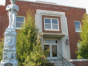
 Floyd County Courthouse and Confederate Monument | |
 Location within the U.S. state of Virginia | |
 Virginia's location within the U.S. | |
| Coordinates: 36°56′N 80°22′W / 36.94°N 80.36°W | |
| Country | |
| State | |
| Founded | 1831 |
| Named for | John Floyd |
| Seat | Floyd |
| Largest town | Floyd |
| Area | |
• Total | 382 sq mi (990 km2) |
| • Land | 381 sq mi (990 km2) |
| • Water | 0.9 sq mi (2 km2) 0.2% |
| Population (2020) | |
• Total | 15,476 |
| • Density | 41/sq mi (16/km2) |
| Time zone | UTC−5 (Eastern) |
| • Summer (DST) | UTC−4 (EDT) |
| Congressional district | 9th |
| Website | www |
Floyd County is a county located in the Commonwealth of Virginia. As of the 2020 census, the population was 15,476.[1] Its county seat is the town of Floyd.[2] Floyd County is included in the Blacksburg-Christiansburg, VA Metropolitan Statistical Area.
Named after Virginia politician John Floyd, the county was established in 1831. The county is located on the high plateau of the Blue Ridge Mountains and surrounded by the Little River. In the 1960s and 1970s, Floyd proved popular with people in the era's counterculture, particularly those who wanted to live in closer contact with nature.
- ^ "Floyd County, Virginia". United States Census Bureau. Retrieved January 30, 2022.
- ^ "Find a County". National Association of Counties. Archived from the original on May 31, 2011. Retrieved June 7, 2011.

