Back فورت بنتون Arabic فورت بنتون ARZ فورت بنتون، مونتانا AZB Форт Бентън Bulgarian Fort Benton Catalan Форт-Бентон (Монтана) CE Fort Benton CEB Fort Benton, Montana CY Fort Benton DAG Fort Benton German
Fort Benton | |
|---|---|
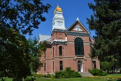
 Chouteau County Courthouse | |
| Nickname: "The Birth Place Of Montana" | |
 Location of Fort Benton, Montana | |
| Coordinates: 47°49′44″N 110°39′21″W / 47.82889°N 110.65583°W | |
| Country | United States |
| State | Montana |
| County | Chouteau |
| Area | |
• Total | 2.29 sq mi (5.94 km2) |
| • Land | 2.29 sq mi (5.94 km2) |
| • Water | 0.00 sq mi (0.00 km2) |
| Elevation | 2,651 ft (808 m) |
| Population (2020) | |
• Total | 1,449 |
| • Density | 631.92/sq mi (243.97/km2) |
| Time zone | UTC-7 (Mountain (MST)) |
| • Summer (DST) | UTC-6 (MDT) |
| ZIP code | 59442 |
| Area code | 406 |
| FIPS code | 30-28000 |
| GNIS feature ID | 2410524[2] |
| Website | www |
Fort Benton is a city in and the county seat of Chouteau County, Montana, United States.[3] Established in 1846, Fort Benton is the oldest continuously occupied settlement in Montana. Fort Benton was the most upstream navigable port on the Mississippi River System, and is considered "the world’s innermost port".[4]
The city's waterfront area, the most important aspect of its 19th century growth, was designated the Fort Benton Historic District, a National Historic Landmark, in 1961.
The population was 1,449 at the 2020 census.[5]
- ^ "ArcGIS REST Services Directory". United States Census Bureau. Retrieved September 5, 2022.
- ^ a b U.S. Geological Survey Geographic Names Information System: Fort Benton, Montana
- ^ "Find a County". National Association of Counties. Archived from the original on May 31, 2011. Retrieved June 7, 2011.
- ^ Spritzer, Don. "The World's Innermost Port". This is Montana. University of Montana. Retrieved January 11, 2023.
- ^ "U.S. Census website". United States Census Bureau. Retrieved November 2, 2021.