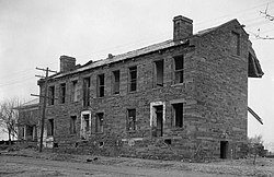
Fort Gibson | |
 Fort Gibson Barracks Building in 1934 | |
| Location | Fort Gibson, Oklahoma |
|---|---|
| Coordinates | 35°48′14″N 95°15′26″W / 35.80389°N 95.25722°W[1] |
| Area | 42 acres (17 ha) |
| Built | 1824 |
| Architect | Matthew Arbuckle |
| NRHP reference No. | 66000631 |
| Significant dates | |
| Added to NRHP | October 15, 1966[2] |
| Designated NHL | December 19, 1960[3] |
Fort Gibson is a historic military site next to the modern city of Fort Gibson, in Muskogee County Oklahoma. It guarded the American frontier in Indian Territory from 1824 to 1888. When it was constructed, the fort was farther west than any other military post in the United States. It formed part of the north–south chain of forts that was intended to maintain peace on the frontier of the American West and to protect the southwestern border of the Louisiana Purchase. The fort succeeded in its peacekeeping mission for more than 50 years, as no massacres or battles occurred there.[4]
The site is now managed by the Oklahoma Historical Society as the Fort Gibson Historical Site and is a National Historic Landmark.
- ^ "Archived copy" (PDF). Archived from the original (PDF) on 2011-07-19. Retrieved 2010-09-09.
{{cite web}}: CS1 maint: archived copy as title (link) - ^ "National Register Information System". National Register of Historic Places. National Park Service. January 23, 2007.
- ^ "Fort Gibson". National Historic Landmark summary listing. National Park Service. Archived from the original on 2009-12-14. Retrieved 2008-01-20.
- ^ Cite error: The named reference
OHCwas invoked but never defined (see the help page).


