Back فرونتيناك Arabic فرونتيناك ARZ فرانتناک، میزوری AZB Frontenac (Missouri) Catalan Фронтенак (Миссури) CE Frontenac (lungsod sa Tinipong Bansa, Missouri) CEB Frontenac, Missouri CY Frontenac (Missouri) German Frontenac (Misuri) Spanish Frontenac (Missouri) EU
Frontenac, Missouri | |
|---|---|
 Plaza Frontenac, October 2017 | |
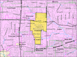
 Location of Frontenac, Missouri | |
 U.S. Census reference map. | |
| Coordinates: 38°37′48″N 90°25′08″W / 38.63000°N 90.41889°W | |
| Country | United States |
| State | Missouri |
| County | St. Louis |
| Government | |
| • Mayor | Kate Hatfield |
| Area | |
• Total | 2.88 sq mi (7.46 km2) |
| • Land | 2.88 sq mi (7.46 km2) |
| • Water | 0.00 sq mi (0.00 km2) |
| Elevation | 640 ft (200 m) |
| Population (2020) | |
• Total | 3,612 |
| • Density | 1,253.73/sq mi (484.02/km2) |
| Time zone | UTC-6 (Central (CST)) |
| • Summer (DST) | UTC-5 (CDT) |
| ZIP code | 63131 |
| Area code | 314 |
| FIPS code | 29-26110[3] |
| GNIS feature ID | 2394829[2] |
| Website | Frontenac, Missouri |
Frontenac is a city in St. Louis County, Missouri, United States. The population was 3,612 at the 2020 census.[4]
The community name is inspired by the New France governor Louis de Buade de Frontenac. Benjamin and Lora Wood, who laid out the community's core called Frontenac Estates, that consisted of 26 two-acre estates, had made frequent trips to Quebec. The community was incorporated as 217 acres (88 ha) in 1947 and annexed another 967 acres (391 ha) in 1948. The community still consists mostly of houses on one-acre lots. French architecture is encouraged in design.[5][6]
- ^ "ArcGIS REST Services Directory". United States Census Bureau. Retrieved August 28, 2022.
- ^ a b U.S. Geological Survey Geographic Names Information System: Frontenac, Missouri
- ^ "U.S. Census website". United States Census Bureau. Retrieved January 31, 2008.
- ^ "United States Census Bureau". Retrieved February 5, 2021.
- ^ "Home / Frontenac, MO".
- ^ "Archived copy" (PDF). Archived from the original (PDF) on July 25, 2011. Retrieved December 25, 2010.
{{cite web}}: CS1 maint: archived copy as title (link)