Back Tregterwolk AF سحاب قمعي Arabic Trichterwolke German Nube embudo Spanish ابر قیفی FA Suppilopilvi Finnish Entonnoir nuageux French ענן משפך HE 漏斗雲 Japanese 깔때기구름 Korean
This article needs additional citations for verification. (October 2012) |


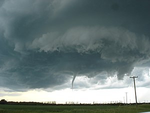
A funnel cloud is a funnel-shaped cloud of condensed water droplets, associated with a rotating column of wind and extending from the base of a cloud (usually a cumulonimbus or towering cumulus cloud) but not reaching the ground or a water surface.[1] A funnel cloud is usually visible as a cone-shaped or needle like protuberance from the main cloud base. Funnel clouds form most frequently in association with supercell thunderstorms, and are often, but not always, a visual precursor to tornadoes. Funnel clouds are visual phenomena, but these are not the vortex of wind itself.[2]
- ^ Glickman, Todd S. (2000). Glossary of Meteorology (2nd ed.). Boston: American Meteorological Society. ISBN 978-1878220349.
- ^ "Funnel cloud". National Weather Service Glossary. NOAA National Weather Service. Retrieved 2019-12-17.