Back جغرافيا فنزويلا Arabic Xeografía de Venezuela AST Геаграфія Венесуэлы BE География на Венецуела Bulgarian Γεωγραφία της Βενεζουέλας Greek Geografía de Venezuela Spanish Venezuelako geografia EU جغرافیای ونزوئلا FA Venezuelan maantiede Finnish Géographie du Venezuela French
 | |
| Continent | South America |
|---|---|
| Region | Caribbean |
| Coordinates | 8°00′N 66°00′W / 8.000°N 66.000°W |
| Area | Ranked 32nd |
| • Total | 912,050[1] km2 (352,140 sq mi) |
| • Land | 96.71% |
| • Water | 3.29% |
| Coastline | 2,800[1] km (1,700 mi) |
| Borders | 5,267 km (3,273 mi)[1] |
| Highest point | Pico Bolívar 4,978 m (16,332 ft)[1] |
| Lowest point | Caribbean Sea 0 metres (0 ft)[1] |
| Exclusive economic zone | 471,507 km2 (182,050 sq mi) |


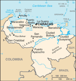
Venezuela is a country in South America, bordering the Caribbean Sea and the North Atlantic Ocean, between Colombia and Guyana. It is situated on major sea and air routes linking North and South America. Located at the northernmost end of South America, Venezuela has a total area of 912,050 km2 (352,140 sq mi) and a land area of 882,050 km2 (340,560 sq mi).[2][1] It is the 32nd largest country and is slightly smaller than Egypt, or half the size of Mexico. Shaped roughly like an inverted triangle, the country has a 2,800 km (1,700 mi) long coastline.[2][1] It is bound on the north by the Caribbean Sea and the Atlantic Ocean, on the east by Guyana, on the south by Brazil, and on the west by Colombia.[2] It has the 55th largest Exclusive Economic Zone of 471,507 km2 (182,050 sq mi). Its maritime territory borders Trinidad and Tobago, Dominica, the Dominican Republic, Grenada, St. Kitts and Nevis, St. Vincent and the Grenadines, France, the United Kingdom, the Netherlands, and the United States. The Guyana–Venezuela territorial dispute has continued since the nineteenth century, with Venezuelan claiming a territory it calls "Guayana Esequiba", which is currently controlled by Guyana.
- ^ a b c d e f g "Venezuela", The World Factbook, Central Intelligence Agency, 12 November 2021, retrieved 12 November 2021.
 This article incorporates text from this source, which is in the public domain.
- ^ a b c Haggerty, Richard A., ed. (1993). Venezuela: a country study (4th ed.). Washington, D.C.: Federal Research Division, Library of Congress. ISBN 0-8444-0747-X. OCLC 25633004.
 This article incorporates text from this source, which is in the public domain.
{{cite encyclopedia}}: CS1 maint: postscript (link)