Back Xeografía de Gambia AST Geographie Gambias German Geografía de Gambia Spanish جغرافیای گامبیا FA Gambian maantiede Finnish Géographie de la Gambie French Geografia del Gambia Italian Geografia Gambii Polish Geografia da Gâmbia Portuguese География Гамбии Russian


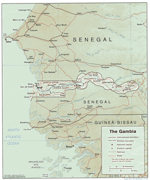
The Gambia is a very small and narrow African country with the border based on the Gambia River. The country is less than 48 kilometres (30 mi) wide at its greatest width. The country's present boundaries were defined in 1889 after an agreement between the United Kingdom and France. It is often claimed by Gambians that the distance of the borders from the Gambia River corresponds to the area that British naval cannon of the time could reach from the river's channel. However, there is no historical evidence to support the story, and the border was actually delineated using careful surveying methods by the Franco-British boundary commission.[1][2] The Gambia is almost an enclave of Senegal and is the smallest country on mainland Africa.