Back جيفرني Arabic جيفرنى ARZ Giverny AST Giverny BR Giverny BUG Giverny Catalan ЖивегӀни CE Giverny CEB Giverny Czech Giverny Danish
This article needs additional citations for verification. (November 2021) |
Giverny | |
|---|---|
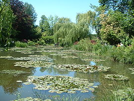
 Water lilies in Claude Monet's garden in Giverny, from which he created his Water Lilies series. (2005) | |
| Coordinates: 49°04′37″N 1°31′48″E / 49.0769°N 1.53°E | |
| Country | France |
| Region | Normandy |
| Department | Eure |
| Arrondissement | Les Andelys |
| Canton | Vernon |
| Intercommunality | Seine Normandie Agglomération |
| Government | |
| • Mayor (2020–2026) | Claude Landais[1] |
Area 1 | 6.46 km2 (2.49 sq mi) |
| Population (2022)[2] | 448 |
| • Density | 69/km2 (180/sq mi) |
| Time zone | UTC+01:00 (CET) |
| • Summer (DST) | UTC+02:00 (CEST) |
| INSEE/Postal code | 27285 /27620 |
| Elevation | 10–139 m (33–456 ft) (avg. 17 m or 56 ft) |
| 1 French Land Register data, which excludes lakes, ponds, glaciers > 1 km2 (0.386 sq mi or 247 acres) and river estuaries. | |
Giverny (French: [ʒivɛʁni]) is a commune in the northern French department of Eure.[3] The village is located on the "right bank" of the river Seine at its confluence with the river Epte. It lies 80 km (50 mi) west-northwest of Paris, in the region of Normandy. It is best known as the location of Claude Monet's garden and home.
Several American Impressionist artists also settled in Giverny, drawn by the landscapes, the overall atmosphere, and the presence of Monet. Other attractions include the Museum of Impressionism Giverny, dedicated to the history of impressionism and the Giverny art colony, and the Hôtel Baudy, which was the center of artistic life in Giverny's heyday. It is now a café and restaurant, with period decoration.
- ^ "Répertoire national des élus: les maires" (in French). data.gouv.fr, Plateforme ouverte des données publiques françaises. 13 September 2022.
- ^ "Populations de référence 2022" (in French). The National Institute of Statistics and Economic Studies. 19 December 2024.
- ^ Commune de Giverny (27285), INSEE


