Back গিজাব জেলা Bengali/Bangla Gīzāb (distrito sa Nasod nga Afghano) CEB ولسوالی گیزاب FA Gizab, Daykundi ID Distretto di Gizab Italian Daerah Gizab Malay Gizab (district) Dutch Gizab distrikt NB Gizab (dystrykt) Polish گيزاب ولسوالۍ PS
Gizab
گیزاب | |
|---|---|
District | |
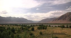
 A view of a valley in the Gizab District | |
Location within Afghanistan[1] | |
| Coordinates: 33°24′00″N 66°16′12″E / 33.40000°N 66.27000°E | |
| Country | |
| Province | Daykundi |
| Elevation | 1,350 m (4,430 ft) |
Gizab (Dari: گیزاب) also spelled as Gezab and Gizu, is a district in the Daykundi Province of Afghanistan. It has a population of about 75,503 and includes Hazara and Pashtun ethnic groups.[2] The main town Gizab is at 1364 m altitude along the Helmand River.
- ^ "District Names". National Democratic Institute. Archived from the original on 29 January 2016. Retrieved 20 October 2015.
- ^ "Gizab" (PDF). United Nations. Afghanistan's Ministry of Rural Rehabilitation and Development. 2006–2007. Archived from the original on 2013-09-22. Retrieved 2012-07-18.
