Back Groot-Antille AF Große Antillen ALS جزر الأنتيل الكبرى Arabic جزر الانتيل الكبرى ARZ Antilles Mayores AST Вялікія Антыльскія астравы BE Вялікія Антыльскія астравы BE-X-OLD Големи Антили Bulgarian ग्रेटर एंटीलिज BH বৃহত্তর আন্তিলীয় দ্বীপপুঞ্জ Bengali/Bangla
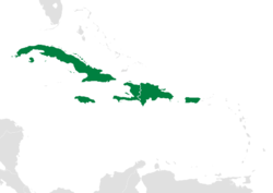
 Location within the Caribbean | |
 Map of the Greater Antilles | |
| Island States | |
| Area | |
• Total | 207,411 km2 (80,081 sq mi) |
| Population (2014) | |
• Total | 38,400,500 |
| • Density | 171.45/km2 (444.1/sq mi) |
| Demonym | Greater Antillean |
| Time zone | EST: UTC-5/EDT: UTC-4 AST: UTC-4/ADT: UTC-3 |
The Greater Antilles[1] is a grouping of the larger islands in the Caribbean Sea, including Cuba, Hispaniola, Puerto Rico, and Jamaica, together with Navassa Island and the Cayman Islands. Seven island states share the region of the Greater Antilles, with Haiti and the Dominican Republic sharing the island of Hispaniola. Together with the Lesser Antilles, they make up the Antilles, which along with the Lucayan Archipelago, form the West Indies in the Caribbean region of the Americas.

While most of the Greater Antilles consists of independent countries, Puerto Rico and Navassa Island are unincorporated territories of the United States, while the Cayman Islands are a British Overseas Territory. The largest island is Cuba, which extends to the western end of the island group. Puerto Rico lies on the eastern end, and the island of Hispaniola, the most populated island, is located in the middle. Jamaica lies to the south of Cuba, while the Cayman Islands are located to the west. The state of Florida is the closest point in the U.S. mainland to the Greater Antilles, while the Florida Keys, though not part of the Greater Antilles, is an island group north of Cuba.

- ^ (Spanish: Antillas Mayores; French: Grandes Antilles; Haitian Creole: Gwo Zantiy; Jamaican Patois: Grieta hAntiliiz)