Back حديقة جبل مولو الوطنية Arabic Taman Nasional Gunung Mulu BAN Национален парк Гунунг Мулу Bulgarian গুনুং মুলু জাতীয় উদ্যান Bengali/Bangla Parc Nacional del Gunung Mulu Catalan Národní park Gunung Mulu Czech Nationalpark Gunung Mulu German Nacia parko Gunung Mulu EO Parque nacional de Gunung Mulu Spanish پارک ملی گونونگ مولو FA
| Gunung Mulu National Park | |
|---|---|
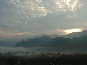
 Mount Mulu viewed from a distance | |
| Location | Marudi District, Miri Division, Sarawak, Malaysia |
| Coordinates | 04°02′33″N 114°48′45″E / 4.04250°N 114.81250°E |
| Area | 528.64 km2 (204.11 sq mi) |
| Established | 1974 |
| Operator | |
| Website | mulupark |
| Official name | Gunung Mulu National Park |
| Type | Natural |
| Criteria | vii, viii, ix, x |
| Designated | 2000 (24th session) |
| Reference no. | 1013 |
| Region | Asia-Pacific |
The Gunung Mulu National Park, also known simply as the Mulu National Park is a national park in Miri Division, Sarawak, Malaysia. It is a UNESCO World Heritage Site that encompasses caves and karst formations in a mountainous equatorial rainforest setting. The park is famous for its caves and the expeditions that have been mounted to explore them and their surrounding rainforest, most notably the Royal Geographical Society Expedition of 1977–1978, which saw over 100 scientists in the field for 15 months. This initiated a series of over 20 expeditions now named the Mulu Caves Project.
The national park is named after Mount Mulu, the second highest mountain in Sarawak.
- ^ "Mulu National Park". Sarawak Forestry Corporation. Archived from the original on 11 July 2018. Retrieved 27 October 2018.
- ^ Cite error: The named reference
managementwas invoked but never defined (see the help page).
