Back سلسلة جبال هامرسلي Arabic سلسلة جبال هامرسلى ARZ Хамърсли (хребет) Bulgarian Hamersley Range CEB Hamersleyovo pohoří Czech Hamersley Range German Cordillera Hamersley Spanish Monts Hamersley French Hamersley Range LLD Hamerslio kalnagūbris LT
| Hamersley Range | |
|---|---|
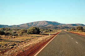
 Outside the town of Paraburdoo, showing part of the Hamersley Range in the background | |
| Highest point | |
| Peak | Mount Meharry |
| Elevation | 1,249 m (4,098 ft) |
| Coordinates | 22°58′S 118°35′E / 22.967°S 118.583°E |
| Geography | |
| Country | Australia |
| State | Western Australia |
| Region | Pilbara |
| Range coordinates | 21°53′S 116°46′E / 21.883°S 116.767°E |
The Hamersley Range is a mountainous region of the Pilbara region of Western Australia. The range was named on 12 June 1861 by explorer Francis Thomas Gregory after Edward Hamersley, a prominent promoter of his exploration expedition to the northwest.[1]
The range is one of the oldest mountain ranges on Earth and primarily consists of ancient rock formations, including banded iron formations (BIFs), that are about 2.5 billion years old. The Pilbara Craton, which underlies the Hamersley Range, dates back to around 3.4 billion years, but the range itself is younger than that. The deformation that began uplift of the region and created the tightly folded rocks of the range began around 2.2 billion years ago, during the Ophthalmia Orogeny. This would make it approximately the 6th oldest mountain range in the world.
Karijini National Park (formerly known as Hamersley Range National Park) lies within the range.
- ^ "North-Western Australia: Gregory's Expedition". Empire. Sydney, NSW. 3 January 1862. p. 2. Retrieved 2 June 2017.
