Back Hay (kapital sa rehiyon) CEB Hay (New South Wales) German هی، نیو ساوت ولز FA Hay (Australie) French Hay MG Hay (Australië) Dutch Hay (Australia) Polish Hay, New South Wales Swedish
| Hay New South Wales | |||||||||
|---|---|---|---|---|---|---|---|---|---|
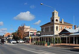
 Looking south down Lachlan Street, the main street of Hay | |||||||||
| Coordinates | 34°30′0″S 144°51′0″E / 34.50000°S 144.85000°E | ||||||||
| Population | 2,882 (2021 census)[1] | ||||||||
| Established | 1859 | ||||||||
| Postcode(s) | 2711 | ||||||||
| Elevation | 93.3 m (306 ft) | ||||||||
| Location | |||||||||
| LGA(s) | Hay Shire | ||||||||
| County | Waradgery | ||||||||
| State electorate(s) | Murray | ||||||||
| Federal division(s) | Farrer | ||||||||
| |||||||||
Hay is a town in the western Riverina region of south western New South Wales, Australia. It is the administrative centre of Hay Shire local government area and the centre of a prosperous and productive agricultural district on the wide Hay Plains.
Located approximately midway between Sydney and Adelaide at the junction of the Sturt, Cobb and Mid-Western Highways, Hay is an important regional and national transport node. The town itself is built beside the Murrumbidgee River, part of the Murray–Darling river system; Australia's largest. The main business district of Hay is situated on the north bank of the river.
