Back مطار هراة الدولي Arabic Flughofm Herat BAR Flughafen Herat German Aeropuerto Internacional de Herāt Spanish Herateko Nazioarteko Aireportua EU میدان هوایی بینالمللی هرات FA Heratin lentoasema Finnish Aéroport d'Hérat French Aeroporto de Herat GL Heráti nemzetközi repülőtér Hungarian
Herat International Airport Persian: میدان هوایی بین المللی هرات | |||||||||||
|---|---|---|---|---|---|---|---|---|---|---|---|
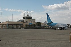
 A Pamir Airways Boeing 737 jet parked at the airport in 2010 | |||||||||||
| Summary | |||||||||||
| Airport type | Public/Military | ||||||||||
| Owner | Government of Afghanistan | ||||||||||
| Operator | GAAC Holding[1] | ||||||||||
| Serves | Herat Province | ||||||||||
| Location | Herat | ||||||||||
| Built | 1960s[2] | ||||||||||
| Elevation AMSL | 3,290 ft / 1,003 m | ||||||||||
| Coordinates | 34°12′36″N 62°13′42″E / 34.21000°N 62.22833°E | ||||||||||
| Map | |||||||||||
 | |||||||||||
| Runways | |||||||||||
| |||||||||||
Herat International Airport, also known as Khwaja Abdullah Ansari International Airport,[5] (IATA: HEA, ICAO: OAHR) is located 10.5 km (6.5 mi) southeast of the city of Herat in western Afghanistan, east of the Herat-Farah road, close to Guzara in the Guzara District of the Herat Province. It is Afghanistan's fourth largest commercial airport after the Kabul International Airport in Kabul, the Ahmad Shah Baba International Airport in Kandahar and the Mawlana Jalal ad-Din Muhammad Balkhi International Airport in Mazar-i-Sharif.[6]
- ^ Faiez, Rahim (9 September 2022). "Taliban: UAE Firm to Run Flight Services on Afghan Airports". The Diplomat. Retrieved 8 December 2022.
- ^ Cite error: The named reference
Area Handbook for Afghanistanwas invoked but never defined (see the help page). - ^ Airport record for Herat Airport at Landings.com. Retrieved 1 August 2013
- ^ "AIP - Important Information - Civil Aviation Authority". Archived from the original on 17 June 2016. Retrieved 20 June 2016.
- ^ Cite error: The named reference
Ansariwas invoked but never defined (see the help page). - ^ Cite error: The named reference
Herat Airport to be Reconstructedwas invoked but never defined (see the help page).
