| Holborn | |
|---|---|
 Old Holborn Town Hall on Gray's Inn Road | |
 | |
| Area | |
| • 1861 | 167 acres (0.68 km2)[1] |
| • 1871 | 167 acres (0.68 km2)[1] |
| • 1881 | 167 acres (0.68 km2)[2] |
| • 1891 | 168 acres (0.68 km2)[3] |
| Population | |
| • 1861 | 45,463[1] |
| • 1871 | 43,520[1] |
| • 1881 | 36,189[2] |
| • 1891 | 33,485[3] |
| History | |
| • Created | 1855 |
| • Abolished | 1900 |
| • Succeeded by | Metropolitan Borough of Holborn Metropolitan Borough of Finsbury |
| Status | District |
| Government | Holborn District Board of Works |
| • HQ | Holborn Town Hall, Gray's Inn Road. |
Holborn was a local government district in the metropolitan area of London to the north west of the City of London from 1855 to 1900.
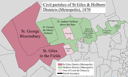
The district was formed by the Metropolis Management Act 1855 from the following Middlesex civil parishes and places:[4]
- The Liberty of Glasshouse Yard
- The Liberty of Saffron Hill, Hatton Garden, Ely Rents and Ely Place
- St Andrew Holborn Above the Bars with St George the Martyr
- St Sepulchre Middlesex
- ^ a b c d "Table 10. Area; inhabited houses, population, number of rated householders and rateable value of property within this district of the Metropolitan board of works". Census of England and Wales 1871 Population tables. Vol. II. Online Historical Population Reports (histpop.org). p. 31. Retrieved 4 August 2010.
- ^ a b "Supplementary Metropolitan tables. Table b. Area, inhabited houses, and population, in 1871 and 1881, number of rated house-holders, and rateable annual value of property assessed in the several parishes, &c. Within the district of the Metropolitan board of works, as defined by 18 and 19 Vict. C. 120". Census of England and Wales 1881 Population tables. Vol. II. Online Historical Population Reports (histpop.org). 1882. p. 30. Retrieved 2 August 2010.
- ^ a b "Division I: London. Table 4. Sanitary areas, distinguishing those under vestries, boards of works and other authorities". Census of England and Wales 1891. Vol II: Registration areas and sanitary districts. Online Historical Population Reports (histpop.org). 1893. p. 17. Retrieved 2 August 2010.
- ^ Metropolis Management Act 1855 (18 & 19 Vict. c.120)
