Back منطقة مركز حمص Arabic Homs District CEB Homsi ringkond ET منطقه حمص FA District de Homs French Հոմսի գավառ HY Distretto di Homs Italian ჰომსის მინტაკა KA Homs-distriktet NN Hims (dystrykt) Polish
Homs District
منطقة حمص | |
|---|---|
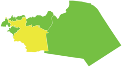
 Map of Homs District within Homs Governorate | |
| Coordinates (Homs): 34°43′51″N 36°42′34″E / 34.7308°N 36.7094°E | |
| Country | |
| Governorate | Homs |
| Seat | Homs |
| Subdistricts | 10 nawāḥī |
| Area | |
• Total | 7,758.92 km2 (2,995.74 sq mi) |
| Population (2004)[1] | |
• Total | 945,299 |
| • Density | 120/km2 (320/sq mi) |
| Geocode | SY0401 |
Homs District (Arabic: منطقة حمص, romanized: manṭiqat Ḥimṣ) is a district of the Homs Governorate in central Syria. The administrative centre is the city of Homs.
The district was split in 2010, when three sub-districts were separated to form the new Taldou District. At the 2004 census, the remaining sub-districts had a total population of 945,299.[1]
- ^ a b "2004 Census Data". UN OCHA. Retrieved 15 October 2015.