Back إدارة هيويتينانغو Arabic Уеуетенанго (департамент) Bulgarian Departamant Huehuetenango BR Huehuetenango (departman) BS Departament de Huehuetenango Catalan Departamento de Huehuetenango CEB Departamento Huehuetenango German Departemento Huehuetenango EO Departamento de Huehuetenango Spanish Huehuetenango (departamendua) EU
Huehuetenango Department
Departmento de Huehuetenango | |
|---|---|
 Counterclockwise from top: Zaculeu in the city of Huehuetenango, Cenotes de Candelaria in Nenton, Hoyo Cimarron in La Trinidad Nenton, Catarata de Pajaj in San Pedro Soloma, Lagartero river in Nenton and Laguna Brava in Nenton Huehuetenango | |
| Coordinates: 15°18′51″N 91°28′33″W / 15.31417°N 91.47583°W | |
| Country | Guatemala |
| Capital | Huehuetenango |
| Municipalities | 31 |
| Government | |
| • Type | Departmental |
| Area | |
| 7,400 km2 (2,900 sq mi) | |
| Highest elevation | 3,352 m (10,997 ft) |
| Lowest elevation | 300 m (1,000 ft) |
| Population (2018)[1] | |
| 1,170,669 | |
| • Density | 160/km2 (410/sq mi) |
| • Urban | 327,297 |
| • Ethnicities | Mam Q'anjob'al Chuj Jakaltek Tektik Awakatek Chalchitek Akatek K'iche Ladino |
| • Religions | Roman Catholicism Evangelicalism Maya |
| Time zone | UTC-6 |
| ISO 3166 code | GT-HU |
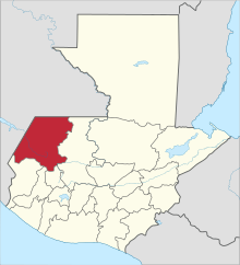
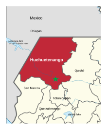
Huehuetenango is one of the 22 departments of Guatemala. It is located in the western highlands and shares the borders with the Mexican state of Chiapas in the north and west; with El Quiché in the east, and Totonicapán, Quetzaltenango and San Marcos in the south. The capital is the city of Huehuetenango.[2]
Huehuetenango's ethnic composition is one of the most diverse in Guatemala. While the Mam are predominant in the department, other Maya groups are the Q'anjob'al, Chuj, Jakaltek, Tektik, Awakatek, Chalchitek, Akatek and K'iche'. Each of these nine Maya ethnic groups speaks its own language.[3][4]
- ^ Citypopulation.de Population of departments in Guatemala
- ^ ITMB 2005.
- ^ "Departamentos de Guatemala - Huehuetenango". Servicio de Información Municipal (SIM). Retrieved 5 June 2008.. Rouanet et al. 1992, pp.4-5. Rodríguez L., p.v. Díaz Camposeco et al. 2008, pp.17, 19.
- ^ Cite error: The named reference
EthnologueAkatekowas invoked but never defined (see the help page).


