Back Uragano Diane EO Huracán Diane Spanish Ouragan Diane French Furacão Diane Portuguese Hurricane Diane SIMPLE พายุเฮอริเคนไดแอน Thai 飓风黛安 Chinese
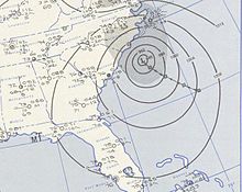
 Weather map of Hurricane Diane on August 19 as it neared North Carolina | |
| Meteorological history | |
|---|---|
| Formed | August 7, 1955 |
| Extratropical | August 21, 1955 |
| Dissipated | August 23, 1955 |
| Category 2 hurricane | |
| 1-minute sustained (SSHWS/NWS) | |
| Highest winds | 105 mph (165 km/h) |
| Lowest pressure | 969 mbar (hPa); 28.61 inHg |
| Overall effects | |
| Fatalities | ≥184 |
| Damage | $832 million (1955 USD) |
| Areas affected | North Carolina, Mid-Atlantic states, New England |
| IBTrACS | |
Part of the 1955 Atlantic hurricane season | |
Hurricane Diane was the first Atlantic hurricane to cause more than an estimated $1 billion in damage (in 1955 dollars, which would be $11,764,962,686 today[1]), including direct costs and the loss of business and personal revenue.[nb 1] It formed on August 7 from a tropical wave between the Lesser Antilles and Cape Verde. Diane initially moved west-northwestward with little change in its intensity, but began to strengthen rapidly after turning to the north-northeast. On August 12, the hurricane reached peak sustained winds of 105 mph (165 km/h), making it a Category 2 hurricane. Gradually weakening after veering back west, Diane made landfall near Wilmington, North Carolina, as a strong tropical storm on August 17, just five days after Hurricane Connie struck near the same area. Diane weakened further after moving inland, at which point the United States Weather Bureau noted a decreased threat of further destruction. The storm turned to the northeast, and warm waters from the Atlantic Ocean helped produce record rainfall across the northeastern United States. On August 19, Diane emerged into the Atlantic Ocean southeast of New York City, becoming extratropical two days later and completely dissipating by August 23.
The first area affected by Diane was North Carolina, which suffered coastal flooding but little wind and rain damage. After the storm weakened in Virginia, it maintained an area of moisture that resulted in heavy rainfall after interacting with the Blue Ridge Mountains, a process known as orographic lift. Flooding affected roads and low-lying areas along the Potomac River. The northernmost portion of Delaware also saw freshwater flooding, although to a much lesser extent than adjacent states. Diane produced heavy rainfall in eastern Pennsylvania, causing the worst floods on record there, largely in the Poconos and along the Delaware River. Rushing waters demolished about 150 road and rail bridges and breached or destroyed 30 dams. The swollen Brodhead Creek virtually submerged a summer camp, killing 37 people. Throughout Pennsylvania, the disaster killed 101 people and caused an estimated $70 million in damage (1955 USD). Additional flooding spread through the northwest portion of neighboring New Jersey, forcing hundreds of people to evacuate and destroying several bridges, including one built in 1831. Storm damage was evident but less significant in southeastern New York.
Damage from Diane was heaviest in Connecticut, where rainfall peaked at 16.86 in (428 mm) near Torrington. The storm produced the state's largest flood on record, which effectively split the state into two by destroying bridges and cutting communications. All major streams and valleys were flooded, and 30 stream gauges reported their highest levels on record. The Connecticut River at Hartford reached a water level of 30.6 ft (9.3 m), the third highest on record there. The flooding destroyed a large section of downtown Winsted, much of which was never rebuilt. Record-high tides and flooded rivers heavily damaged Woonsocket, Rhode Island. In Massachusetts, flood water levels surpassed those during the 1938 New England Hurricane, breaching multiple dams and inundating adjacent towns and roads. Throughout New England, 206 dams were damaged or destroyed, and about 7,000 people were injured. Nationwide, Diane killed at least 184 people and destroyed 813 houses, with another 14,000 homes heavily damaged. In the hurricane's wake, eight states were declared federal disaster areas, and the name Diane was retired.
- ^ 1634–1699: McCusker, J. J. (1997). How Much Is That in Real Money? A Historical Price Index for Use as a Deflator of Money Values in the Economy of the United States: Addenda et Corrigenda (PDF). American Antiquarian Society. 1700–1799: McCusker, J. J. (1992). How Much Is That in Real Money? A Historical Price Index for Use as a Deflator of Money Values in the Economy of the United States (PDF). American Antiquarian Society. 1800–present: Federal Reserve Bank of Minneapolis. "Consumer Price Index (estimate) 1800–". Retrieved February 29, 2024.
Cite error: There are <ref group=nb> tags on this page, but the references will not show without a {{reflist|group=nb}} template (see the help page).