Back ایندیپندنس، کالیفورنیا AZB Индипендънс (Калифорния) Bulgarian Independence (Califòrnia) Catalan Индепенденс (Калифорни) CE Independence (lungsod sa Tinipong Bansa, California) CEB Independence (Kalifornien) German Independence (Kalifornio) EO Independence (condado de Inyio) Spanish Independence (Kalifornia) EU ایندیپندنس، کالیفرنیا FA
Independence | |
|---|---|
 | |
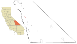
 Location in Inyo County and the state of California | |
| Coordinates: 36°49′39″N 118°12′48″W / 36.82750°N 118.21333°W | |
| Country | |
| State | |
| County | Inyo |
| Area | |
• Total | 4.870 sq mi (12.612 km2) |
| • Land | 4.867 sq mi (12.605 km2) |
| • Water | 0.003 sq mi (0.007 km2) 0.057% |
| Elevation | 3,904 ft (1,190 m) |
| Population | |
• Total | 593 |
| • Density | 120/sq mi (47/km2) |
| Time zone | UTC-8 (Pacific (PST)) |
| • Summer (DST) | UTC-7 (PDT) |
| ZIP Code | 93526 |
| Area codes | 442/760 |
| FIPS code | 06-36350 |
| GNIS feature ID | 2408418[2] |
Independence is an unincorporated, census-designated place in Inyo County, California. Independence is located 41 miles (66 km) south-southeast of Bishop,[4] at an elevation of 3930 feet (1198 m).[2] It is the county seat of Inyo County, California. The population of this census-designated place was 669 at the 2010 census, up from 574 at the 2000 census.
- ^ "2010 Census U.S. Gazetteer Files – Places – California". United States Census Bureau.
- ^ a b c U.S. Geological Survey Geographic Names Information System: Independence, California
- ^ "US Census Bureau". www.census.gov. Retrieved August 28, 2024.
- ^ Durham, David L. (1998). California's Geographic Names: A Gazetteer of Historic and Modern Names of the State. Clovis, Calif.: Word Dancer Press. p. 1172. ISBN 1-884995-14-4.
