Back مقاطعة إنيو (كاليفورنيا) Arabic İnyo qraflığı (Kaliforniya) AZ Inyo County, Kalifornien BAR Иньо Bulgarian ইনয়ো কাউন্টি, ক্যালিফোর্নিয়া Bengali/Bangla ইনয়ো কাউন্টি, ক্যালিফোর্নিয়া BPY Comtat d'Inyo Catalan Иньо (гуо, Калифорни) CE Inyo County CEB ناوچەی ینیۆ (کالیفۆرنیا) CKB
County of Inyo | |
|---|---|
 Wildflowers blooming in Death Valley after a wet winter | |
 Interactive map of Inyo County | |
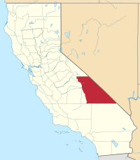
 Location in the state of California | |
| Coordinates: 36°35′N 117°25′W / 36.583°N 117.417°W | |
| Country | |
| State | |
| Region | Eastern California |
| Established | March 22, 1866[1] |
| Named for | ɨnnɨyun 'it's dangerous' in Timbisha[2] |
| County seat | Independence |
| Largest city | Bishop |
| Government | |
| • Type | Council–CAO |
| • Body | Board of Supervisors |
| • Chair[4] | Jennifer Roeser |
| • Vice Chair[5] | Scott Marcellin |
| • Board of Supervisors | Supervisors[3]
|
| • County Administrator[6] | Leslie Chapman |
| Area | |
• Total | 10,227 sq mi (26,490 km2) |
| • Land | 10,181 sq mi (26,370 km2) |
| • Water | 46 sq mi (120 km2) |
| Highest elevation | 14,505 ft (4,421 m) |
| Lowest elevation | −282 ft (−86 m) |
| Population | |
• Total | 19,016 |
| • Density | 1.9/sq mi (0.7/km2) |
| GDP | |
| • Total | $1.355 billion (2022) |
| Time zone | UTC−8 (Pacific Time Zone) |
| • Summer (DST) | UTC−7 (Pacific Daylight Time) |
| Area codes | 442/760 |
| FIPS code | 06-027 |
| GNIS feature ID | 1804637 |
| Congressional district | 3rd |
| Website | www |
Inyo County (/ˈɪnjoʊ/ ) is a county in the eastern central part of the U.S. state of California, located between the Sierra Nevada and the state of Nevada. In the 2020 census, the population was 19,016.[9] The county seat is Independence.[11] Inyo County is on the east side of the Sierra Nevada and southeast of Yosemite National Park in Central California. It contains the Owens River Valley; it is flanked to the west by the Sierra Nevada and to the east by the White Mountains and the Inyo Mountains. With an area of 10,192 square miles (26,400 km2), Inyo is the second-largest county by area in California, after San Bernardino County. Almost half of that area is within Death Valley National Park. However, with a population density of 1.8 people per square mile, it also has the second-lowest population density in California, after Alpine County.
- ^ "Inyo County". Geographic Names Information System. United States Geological Survey, United States Department of the Interior. Retrieved April 8, 2015.
- ^ William Bright & John McLaughlin, "Inyo Redux", Names 48:147-150 (2000)
- ^ "Board of Supervisors | Inyo County California".
- ^ "District 4 | Inyo County California".
- ^ "District 3 | Inyo County California".
- ^ "County Administrative Officer | Inyo County California".
- ^ "Mount Whitney". Peakbagger.com. Archived from the original on April 10, 2015. Retrieved April 9, 2015.
- ^ "Highest and Lowest Elevations". United States Geological Survey. Retrieved April 29, 2021.
- ^ a b "Inyo County, California". United States Census Bureau. Retrieved January 30, 2022.
- ^ "Gross Domestic Product: All Industries in Inyo County, CA". Federal Reserve Economic Data. Federal Reserve Bank of St. Louis.
- ^ "Find a County". National Association of Counties. Archived from the original on May 31, 2011. Retrieved June 7, 2011.
