Back ঈশ্বরগঞ্জ উপজেলা Bengali/Bangla ঈশ্বরগঞ্জ উপজিলা BPY ایشرگانج FA Ishwarganj French ईश्वरगंज उपज़िला HI Ishwarganj Italian Ишваргандж (подокруг) Russian 伊茨華爾甘傑烏帕齊拉 Chinese Ishwarganj Tìn ZH-MIN-NAN
Ishwarganj
ঈশ্বরগঞ্জ | |
|---|---|
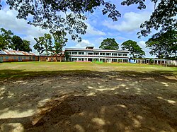
 Mollikpur Laksmiganj High School | |
 | |
| Coordinates: 24°39′0″N 90°30′0″E / 24.65000°N 90.50000°E | |
| Country | |
| Division | Mymensingh |
| District | Mymensingh |
| Headquarters | Ishwarganj |
| Government | |
| • Type | Upazila Parishad |
| • Chairman | A. K. M. Faridullah |
| • MP (Mymensingh-8) | CURRENTLY NO ONE |
| Area | |
• Total | 280.43 km2 (108.27 sq mi) |
| Population | |
• Total | 404,613 |
| • Density | 1,400/km2 (3,700/sq mi) |
| Time zone | UTC+6 (BST) |
| Postal code | 2280[2] |
| Area code | 09027[3] |
| Website | iswarganj |
Ishwarganj (Bengali: ঈশ্বরগঞ্জ) is an administrative area in north-eastern Bangladesh. It is an upazila in Mymensingh District.
- ^ National Report (PDF). Population and Housing Census 2022. Vol. 1. Dhaka: Bangladesh Bureau of Statistics. November 2023. p. 401. ISBN 978-9844752016.
- ^ "Bangladesh Postal Code". Dhaka: Bangladesh Postal Department under the Department of Posts and Telecommunications of the Ministry of Posts, Telecommunications and Information Technology of the People's Republic of Bangladesh. 20 October 2024.
- ^ "Bangladesh Area Code". China: Chahaoba.com. 18 October 2024.