Back كالاي Arabic كالاى ARZ ဝေင်ꩻကလေး BLK Kalay German Kalej EO Kalay Spanish Kalaymyo French ကလေးမြို့ MY Kalay Polish Калемьо Russian
Kalay
ကလေး | |
|---|---|
Town | |
 | |
| Coordinates: 23°11′40″N 94°01′25″E / 23.19444°N 94.02361°E | |
| Country | |
| Region | |
| District | Kalay District |
| Township | Kalay Township |
| Founded | 3 February 966 |
| Area | |
• Total | 2,337.74 km2 (902.61 sq mi) |
| Elevation | 140 m (450 ft) |
| Population | 348,573 |
| Time zone | UTC+6.30 (MST) |
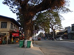
Kalay (Burmese: ကလေး), also known as Kale, is a town in the Sagaing Region of Myanmar. It is located upstream from Mandalay and Monywa on the Myittha River, a tributary of the Chindwin River. The town is the district headquarters of the Kalay District.[1] It has gained importance with trans border movement enabled between Myanmar and India following the 165 kilometres (103 mi) Tamu–Kalay section of India–Myanmar–Thailand Trilateral Highway built by the Border Roads Organization of India under the Look-East Connectivity policy.[2] Consequently, Kalay is now one of the fastest developing towns in Myanmar.
Kalay has several notable prisons, to which people from all across the region are transported.[3]
- ^ "Kalaymyo (2009-2010)". Kalay Township. 2010-03-01. Retrieved 2010-09-27.
- ^ Burma file a question of democracy. India Research Press. 2003. p. 131. ISBN 978-81-88353-12-5. Retrieved 2010-09-27.
- ^ Lintner, Bertil (2009). The resistance of the monks: Buddhism and activism in Burma. Human Rights Watch. p. 58. ISBN 978-1-56432-544-0.
