Back کانیوهی، هاوایی AZB Kaneohe Catalan Канеоге (Гавай) CE Kāne‘ohe CEB Kaneohe DAG Kāneʻohe German Kaneohe Spanish Kaneohe (Hawaii) EU کانیوهی، هاوایی FA Kaneohe French
Kāneʻohe | |
|---|---|
| Kāneʻohe | |
 View from the Nuʻuanu Pali Lookout of Kaneʻohe | |
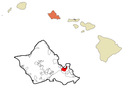
 Location in Honolulu County and the state of Hawaii | |
| Coordinates: 21°24′33″N 157°47′57″W / 21.40917°N 157.79917°W | |
| Country | |
| State | |
| County | Honolulu |
| Area | |
• Total | 8.46 sq mi (21.91 km2) |
| • Land | 6.54 sq mi (16.95 km2) |
| • Water | 1.92 sq mi (4.97 km2) |
| Elevation | 92 ft (28 m) |
| Population (2020) | |
• Total | 37,430 |
| • Density | 5,720.62/sq mi (2,208.90/km2) |
| Time zone | UTC-10 (Hawaiian Standard Time HST) |
| ZIP code | 96744 |
| Area code | 808 |
| FIPS code | 15-28250 |
| GNIS feature ID | 0360391 |

Kaneohe or Kāneʻohe (Hawaiian pronunciation: [kaːneˈʔohe]) is a census-designated place (CDP) included in the City and County of Honolulu and in Hawaiʻi state District of Koʻolaupoko on the island of Oʻahu. In the Hawaiian language, kāne ʻohe means "bamboo man". According to an ancient Hawaiian story, a local woman compared her husband's cruelty to the sharp edge of cutting bamboo; thus the place was named Kāneʻohe or "bamboo man".
The population was 37,430 at the 2020 census. Kāneʻohe is the largest of several communities along Kāneʻohe Bay and one of the two largest residential communities on the windward side of Oʻahu (the other is Kailua). The town's commercial center is spread mostly along Kamehameha Highway.
Features of note are Hoʻomaluhia Botanical Garden and the Hawaiʻi National Veterans Cemetery. Access to Kāneʻohe Bay is mainly from the public pier and boat ramp at nearby Heʻeia Kea.
- ^ "2020 U.S. Gazetteer Files". United States Census Bureau. Retrieved December 18, 2021.
