Back كوشامبي Arabic كوشامبى ARZ कौशांबी जिला BH কৌশাম্বী জেলা Bengali/Bangla Kaushambi District CEB Kaushambi (distrikt) Danish Kaushambi (Distrikt) German Distrito de Kaushambi Spanish Kaushambi barrutia EU بخش کاوشامبی FA
Kaushambi district | |
|---|---|
 Ruins of Ghoshtiram Buddhist monastery in Kosambi | |
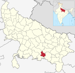
 Location of Kaushambi district in Uttar Pradesh | |
| Country | |
| State | Uttar Pradesh |
| Division | Prayagraj |
| Headquarters | Manjhanpur |
| Tehsils manjhanpur, sirathu, chail | 3 |
| Government | |
| • Lok Sabha constituencies | Kaushambi (Lok Sabha constituency) |
| • Vidhan Sabha constituencies | 1. Chail 2. Manjhanpur 3. Sirathu |
| Area | |
• Total | 1,903.17 km2 (734.82 sq mi) |
| Population (2011) | |
• Total | 1,599,596 |
| • Density | 840/km2 (2,200/sq mi) |
| • Urban | 124,456 |
| Demographics | |
| • Literacy | 63.69 % |
| Time zone | UTC+05:30 (IST) |
| Website | kaushambi |
Kaushambi district is a district in the state of Uttar Pradesh in India. Manjhanpur is the district headquarters. The district was carved from Prayagraj district on 4 April 1997. Manauri Bajar connects Prayagraj and Kaushambi districts by railway over a bridge on SH-95. Manjhanpur is south-west of Prayagraj on the north bank of the Yamuna river, about 55 kilometres (34 mi) from the city. It is surrounded by Chitrakoot district on the south, Pratapgarh district on the north, Prayagraj district on the east and Fatehpur district on the west. Kaushambi is part of Prayagraj division. The nearest railway station, in Bharwari, connects with Delhi, Prayagraj, Kolkata, Gaya and Kanpur.kaushambi district have two river like yamuna ganga.