Back খাজা বাহা উদ্দিন জেলা Bengali/Bangla Khwājah Bahāwuddīn CEB ولسوالی خواجه بهاالدین FA Distretto di Khwaja Baha Wuddin Italian Daerah Khwaja Baha Wuddin Malay خواجه بهاوالدين ولسوالۍ PS Khwaja Bahawuddin (distrikt) Swedish Xo‘ja Bahouddin tumani, Taxor UZ Khwaja Baha Wuddin (huyện) VI
Khwaja Bahauddin District | |
|---|---|
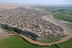
 View of Khwaja Bahauddin's urban center | |
 Location of Khwaja Bahauddin in Takhar Province | |
| Coordinates: 37°20′N 69°32′E / 37.34°N 69.54°E | |
| Country | |
| Province | Takhār Province |
| Area | |
• Total | 178.2 km2 (68.8 sq mi) |
| Population (2019)[2] | |
• Total | 25,852 |
| • Density | 145/km2 (380/sq mi) |
| Time zone | UTC+4:30 (Afghanistan Standard Time) |
| Post code | 3757[3] |
Khwaja Bahauddin District is a district of Takhar Province, Afghanistan. The district was created from a portion of Yangi Qala District in 2005.[4][5] 25 villages are located in Khwaja Bahauddin.[1]
- ^ a b "Summary of District Development Plan: Khwaja Bahauddin" (PDF). mrrd-nabdp.org. Archived from the original on 19 April 2014. Retrieved 6 August 2020.
{{cite web}}: CS1 maint: unfit URL (link) - ^ "Estimated population of Afghanistan 2019-2020" (PDF). nsia.gov.af. p. 29. Archived from the original (PDF) on 9 June 2020. Retrieved 6 August 2020.
- ^ "Khwaha Bahawuddin Post Codes". worldpostalcodes.com. Retrieved 6 August 2020.
- ^ "Maps of Afghanistan". arcgis.com. Retrieved 7 August 2020.
- ^ "329 to 398 district matching". 2005. Archived from the original on 22 March 2016. Retrieved 7 August 2020.