Back Kisarawe (distrito) CEB Kisarawe (Distrikt) German Περιοχή Κισαράουε Greek Wilaya ya Kisarawe Swahili Kisarawe (huyện) VI Kisarawe District ZU
Kisarawe District
Wilaya ya Kisarawe (Swahili) | |
|---|---|
|
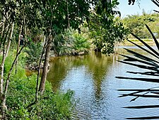
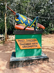
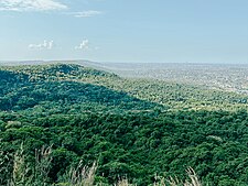
From top to bottom: Minaki dam in Pugu Hills Forest Reserve of Kisarawe, Tanzanian Grasshopper sculpture in Kisarawe & View of Dar es Salaam from the Pugu Hills | |
| Nickname: Home of the Pugu Hills | |
 Kisarawe District in Pwani | |
| Coordinates: 7°15′44″S 38°44′12″E / 7.26222°S 38.73667°E | |
| Country | |
| Region | Pwani Region |
| Named for | Kisarawe Town |
| Capital | Kisarawe |
| Area | |
• Total | 5,031 km2 (1,942 sq mi) |
| • Rank | 4th in Pwani |
| Population (2022) | |
• Total | 159,226 |
| • Rank | 5th in Pwani |
| • Density | 32/km2 (82/sq mi) |
| Ethnic groups | |
| • Settler | Swahili |
| • Native | Zaramo & Ndengereko |
| Time zone | UTC+3 (EAT) |
| Tanzanian Postcode | 614 |
| Website | Kisarawe District Council |
| Symbols of Tanzania | |
| Bird |  |
| Mammal |  |
Kisarawe District Council (Wilaya ya Kisarawe, in Swahili) is one of eight administrative districts of Pwani Region in Tanzania. The District covers an area of 5,031 km2 (1,942 sq mi).[1] It is bordered to the east by Dar es Salaam Region's Ilala and Ubungo Municipal Councils. The Kibaha District and Kibaha Town Council border the district to the north, and the Mkuranga District and Kibiti District border it to the south-east. By the Rufiji District to the south, and the Morogoro District of the Morogoro Region to the west. The district is comparable in size to the land area of Trinidad and Tobago.[2] The town of Kisarawe serves as its administrative capital. According to the 2022 Tanzania National Census, the population of the District was 159,226.[3][4]
- ^ "Tanzania: Coastal Zone(Districts and Wards) - Population Statistics, Charts and Map".
- ^ 5,130 km2 (1,980 sq mi) for Trinidad and Tobago at "Area size comparison". Nation master. 2022. Retrieved 16 September 2023.
- ^ "Tanzania: Administrative Division (Regions and Districts) - Population Statistics, Charts and Map". www.citypopulation.de. Retrieved 2024-02-11.
- ^ 2012 Census database Archived 2016-03-05 at the Wayback Machine


