| Ruda Woda | |
|---|---|
Duckie, Dudzkie
| |
|
Top: Panorama of northern part of Lake Ruda Woda, near the entrance to the Elbląg Canal; Middle: Sentinel-2 satellite image of the lake, June 2024; Bottom: Seasonal changes over the lake near the village of Wilamowo | |
| Location | Powiśle |
| Coordinates | 53°52′N 19°49′E / 53.86°N 19.81°E |
| Type | Ribbon lake |
| Primary inflows | Drela |
| Basin countries | |
| Max. length | 12.01 km (7.46 mi) |
| Max. width | 1.65 km (1.03 mi) |
| Min. width | 0.286 km (0.178 mi) |
| Surface area | 6.134 km2 (2.368 sq mi) |
| Average depth | 10.3 m (34 ft) |
| Max. depth | 27.4 m (90 ft) |
| Shore length1 | 35.8 km (22.2 mi) |
| Surface elevation | 99.5 m (326 ft) |
| Islands | 7 |
| 1 Shore length is not a well-defined measure. | |
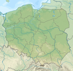
Lake Ruda Woda ([ˈruda vɔda]; German: Röthloff See) is a long freshwater ribbon lake in Powiśle region in northern Poland. The lake lies entirely within Gmina Małdyty in Warmian-Masurian Voivodeship and is an integral part of the Elbląg Canal. Stretching 12 kilometres (7.5 mi) in length, the lake features four distinct bays and several islands. The lakebed is diverse, with numerous depressions and shallows. Shores are mostly high and steep, surrounded by temperate deciduous forest, with only the southern and northern parts bordered by fields and meadows.
Lake’s surroundings are sparsely populated with several villages located nearby, including Wilamowo, Szymonowo, Szymonówko, Sople and Liksajny.
The lake provides fishing and recreation opportunities, including sailing, kayaking and jet skiing. Several public piers scatter around the lake facility access to convenient entry points for swimming and sunbathing. Scouting camp is located in the northern part of the lake.


