Back Landsat 4 Czech لندست ۴ FA Landsat 4 French Landsat 4 Hungarian Landsat 4 ID ランドサット4号 Japanese Landsat 4 Polish Landsat 4 Portuguese Landsat 4 Ukrainian 陸地衛星4號 Chinese
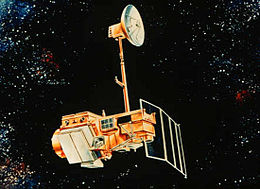
 Artist's rendering of Landsat 5, which is identical to Landsat 4. | |
| Mission type | Earth imaging |
|---|---|
| Operator | NASA / NOAA |
| COSPAR ID | 1982-072A |
| SATCAT no. | 13367 |
| Spacecraft properties | |
| Bus | Multimission Modular Spacecraft |
| Manufacturer | GE Astro Space |
| Launch mass | 1,941 kilograms (4,279 lb) |
| Dry mass | 1,407 kilograms (3,102 lb) |
| Start of mission | |
| Launch date | July 16, 1982 |
| Rocket | Delta 3920 |
| Launch site | Vandenberg AFB SLC-2W |
| End of mission | |
| Deactivated | December 14,1993 |
| Orbital parameters | |
| Reference system | Geocentric |
| Regime | Sun-synchronous |
| Perigee altitude | 700 kilometers (430 mi) |
| Apogee altitude | 704 kilometers (437 mi) |
| Inclination | 98.2 degrees |
| Period | 98.81 minutes |
| Repeat interval | 16 days |
| Epoch | August 17, 1982[1] |
Landsat 4 is the fourth satellite of the Landsat program. It was launched on July 16, 1982, with the primary goal of providing a global archive of satellite imagery. Although the Landsat Program is managed by NASA, data from Landsat 4 was collected and distributed by the U.S. Geological Survey. Landsat 4 science operations ended on December 14, 1993, when the satellite lost its ability to transmit science data, far beyond its designed life expectancy of five years. The satellite housekeeping telemetry and tracking continued to be maintained by NASA until it was decommissioned on June 15, 2001.
- ^ McDowell, Jonathan. "Satellite Catalog". Jonathan's Space Page. Retrieved June 16, 2013.