Back لارغو (ماريلند) Arabic لارقو، مریلند AZB Largo (Maryland) Catalan Largo (lungsod sa Tinipong Bansa, Maryland) CEB Largo (Maryland) Spanish Largo (Maryland) EU لارگوو، مریلند FA لاگو (مريلند) GLK Largo (Maryland) Italian Ларго (Мэриленд) KK
This article has multiple issues. Please help improve it or discuss these issues on the talk page. (Learn how and when to remove these messages)
|
Largo, Maryland | |
|---|---|
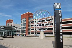
 Downtown Largo station in Downtown Largo | |
 Location of Largo, Maryland | |
| Coordinates: 38°52′37″N 76°49′50″W / 38.87694°N 76.83056°W | |
| Country | |
| State | |
| County | |
| Named for | Largo Bay, Scotland[1] |
| Area | |
• Total | 3.06 sq mi (7.93 km2) |
| • Land | 3.06 sq mi (7.93 km2) |
| • Water | 0.00 sq mi (0.00 km2) |
| Elevation | 174 ft (53 m) |
| Population (2020) | |
• Total | 11,605 |
| • Density | 3,790.01/sq mi (1,463.43/km2) |
| Time zone | UTC−5 (Eastern (EST)) |
| • Summer (DST) | UTC−4 (EDT) |
| ZIP code | 20774 |
| Area code(s) | 301, 240 |
| FIPS code | 24-45825 |
| GNIS feature ID | 0597664 |

Largo is an unincorporated area and census-designated place in Prince George's County, Maryland, United States.[3] The population was 11,605 at the 2020 census.[4]
Largo is located just east of the Capital Beltway (I-95/495) and is home to Prince George's Community College and Largo High School. Six Flags America amusement park (formerly known as Wild World and Adventure World) is to the east in Woodmore, and FedExField, the Washington Commanders's stadium, is across the Capital Beltway in Summerfield. Watkins Regional Park in Kettering just to the east of Largo (operated by the Maryland-National Capital Park and Planning Commission) has an old-fashioned carousel, miniature train ride, miniature golf, the Old Maryland Farm, a playground, and animals on display.[5] Largo is not a post office designation, but is at the northern end of the Greater Upper Marlboro ZIP code area.
Since the transit system's expansion in late 2004, Downtown Largo station has served as the eastern end of the Blue and Silver Lines of the Washington Metro.
- ^ "ePodunk". www.epodunk.com. Archived from the original on May 7, 2018. Retrieved May 6, 2018.
- ^ "2020 U.S. Gazetteer Files". United States Census Bureau. Retrieved April 26, 2022.
- ^ U.S. Geological Survey Geographic Names Information System: Largo, Maryland
- ^ "Largo CDP, Maryland". United States Census Bureau. Retrieved April 15, 2022.
- ^ "Watkins Regional Park". Archived from the original on June 25, 2013. Retrieved May 1, 2013.