Back Leilani Estates Catalan Лейлани-Естейтс (Гавай) CE Leilani Estates (lungsod sa Tinipong Bansa, lat 19,47, long -154,92) CEB Leilani Estates Spanish Leilani Estates French لیلانی استیتس (هاوايي) GLK Leilani Estates Italian Leilani Estates (Hawaii) LLD لیلانی استیتز (هاوایی) MZN लेइलानी एस्टेट्स, हवाई NEW
Leilani Estates, Hawaii | |
|---|---|
 | |
| Coordinates: 19°28′25″N 154°55′13″W / 19.47361°N 154.92028°W | |
| Country | United States |
| State | Hawaii |
| County | Hawaiʻi |
| Area | |
• Total | 4.04 sq mi (10.45 km2) |
| • Land | 4.04 sq mi (10.45 km2) |
| • Water | 0.00 sq mi (0.00 km2) |
| Elevation | 771 ft (235 m) |
| Population (2020) | |
• Total | 1,139 |
| • Density | 282.28/sq mi (109.00/km2) |
| Time zone | UTC-10 (Hawaii-Aleutian Standard Time Zone) |
| ZIP code | 96778[2] |
| Area code | 808 |
| FIPS code | 15-44562 |
| GNIS feature ID | 1852580 |


Leilani Estates is a census-designated place (CDP) in Hawaiʻi County, Hawaii, United States located in the District of Puna. The subdivision was formed in 1964.[3] The population was 1,139 at the 2020 census,[4] down from 1,560 at the 2010 census,[5] and up from 1,046 at the 2000 census.
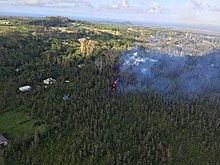
The 2018 lower Puna eruption of Kīlauea Volcano, which occurred within and around the subdivision, claimed many homes and displaced an unknown number of Leilani Estates residents.[6] Accessing the entire resulting solid lava rock flow field has been prohibited, as per the Mayor's 12/6/18 Emergency Proclamation,[7] with fines up to $5,000 for violations. As of January 2019, in further effort to prevent the private subdivision from becoming a public attraction, the Leilani Community Association began enforcing regulations regarding no parking on private roads, no trespassing on private property, and no tours being conducted in the subdivision.
- ^ "2020 U.S. Gazetteer Files". United States Census Bureau. Retrieved December 18, 2021.
- ^ "Leilani Estates HI ZIP Code". zipdatamaps.com. 2024. Retrieved February 5, 2024.
- ^ "Chapter "Leilani Estates History" at leilaniestates.org". Retrieved May 31, 2018.
- ^ Cite error: The named reference
DecennialCensuswas invoked but never defined (see the help page). - ^ "Geographic Identifiers: 2010 Demographic Profile Data (G001): Leilani Estates CDP, Hawaii". American Factfinder. U.S. Census Bureau. Retrieved June 1, 2017.[dead link]
- ^ Dayton, Kevin (November 30, 2022). "Why are homes allowed to be built in lava zones? Mauna Loa eruption has Hawaii residents wondering". USA TODAY. Retrieved 2022-12-03.
- ^ "County of Hawaii - Civil Defense Alerts and Information - Sixth Supplementary Emergency Proclamation". www.hawaiicounty.gov. Retrieved 2019-01-10.
