| Level Mountain | |
|---|---|
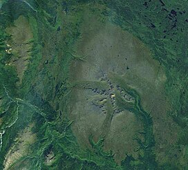
 Satellite image of Level Mountain (middle-right) and Heart Peaks (upper-left corner). This image is approximately 80 km (50 mi) east–west. | |
| Highest point | |
| Peak | Meszah Peak[1][2] |
| Elevation | 2,164 m (7,100 ft)[1][2] |
| Listing | Mountains of British Columbia |
| Coordinates | 58°28′43″N 131°26′14″W / 58.47861°N 131.43722°W[1][3] |
| Dimensions | |
| Length | 70 km (43 mi)[4] |
| Width | 45 km (28 mi)[4] |
| Area | 1,800 km2 (690 sq mi)[5] |
| Volume | 860 km3 (210 cu mi)[5] |
| Geography | |
| Country | Canada[6] |
| Province | British Columbia[6] |
| District | Cassiar Land District[8] |
| Parent range | Nahlin Plateau[7] |
| Topo map(s) | NTS 104J12 Dudidontu River[8] NTS 104J11 Granite Lake[8] NTS 104J6 Beatty Creek[8] NTS 104J5 Ketchum Lake[8] NTS 104J3 Tahltan River[8] |
| Geology | |
| Formed by | Shield volcano (basal feature), stratovolcano, lava domes, spatter cones, tuyas (overlying features)[9] |
| Rock age | Less than 15 million years old[10] |
| Rock type(s) | Alkali basalt, ankaramite, trachyte, rhyolite, phonolite[11] |
| Volcanic region | Northern Cordilleran Province[12] |
| Last eruption | Unknown[6] |
Level Mountain is a large volcanic complex in the Northern Interior of British Columbia, Canada. It is located 50 kilometres (31 miles) north-northwest of Telegraph Creek and 60 kilometres (37 miles) west of Dease Lake on the Nahlin Plateau. With a maximum elevation of 2,164 metres (7,100 feet), it is the second-highest of four large complexes in an extensive north–south trending volcanic region. Much of the mountain is gently sloping; when measured from its base, Level Mountain is about 1,100 metres (3,600 feet) tall, slightly taller than its neighbour to the northwest, Heart Peaks. The lower, broader half of Level Mountain consists of a shield-like structure while its upper half has a more steep, jagged profile. Its broad summit is dominated by the Level Mountain Range, a small mountain range with prominent peaks cut by deep valleys. These valleys serve as a radial drainage for several small streams that flow from the mountain. Meszah Peak is the only named peak in the Level Mountain Range.
The mountain began forming about 15 million years ago and has experienced volcanism up until geologically recent times. There have been four stages of activity throughout the long volcanic history of Level Mountain. The first stage commenced 14.9 million years ago with the eruption of voluminous lava flows; these created a large shield volcano. The second stage began 7.1 million years ago to form a structurally complicated stratovolcano located centrally atop the shield. A series of lava domes was established during the third stage, which began 4.5 million years ago. This was followed by the fourth and final stage with the eruption of lava flows and small volcanic cones in the last 2.5 million years. A wide range of rock types were produced during these stages, namely ankaramites, alkali basalts, trachybasalts, mugearites, hawaiites, phonolites, trachytes and rhyolites. Alkali basalts and ankaramites are the most voluminous and form most of Level Mountain. The remaining rock types are less extensive and are largely restricted to the central region of the volcanic complex. Several types of volcanic eruptions produced these rocks.
Level Mountain lies in one of many ecoregions throughout British Columbia. It can be ecologically divided into three sections: lodgepole pine and white spruce forests at its base, bog birch and subalpine fir forests on its flanks, and an alpine climate at its summit. The extent and flatness of the alpine on Level Mountain have produced many Arctic affinities that are particularly noticeable in the local biota. Several animal species thrive in the area of Level Mountain, caribou being the most abundant. A trading post was established at Level Mountain in the 1890s, followed by geological studies of the mountain from the 1920s onwards. This remote area of Cassiar Land District has a relatively dry environment compared to the Coast Mountains in the west. Due to its remoteness, Level Mountain can only be accessed by air or by trekking great distances on foot. The closest communities are more than 30 kilometres (19 miles) away from the mountain.
- ^ a b c "Level Mountain: Synonyms & Subfeatures". Global Volcanism Program. Smithsonian Institution. Archived from the original on 2021-06-04. Retrieved 2021-06-04.
- ^ a b Holland, Stuart S. (1976). Landforms of British Columbia: A Physiographic Outline (PDF) (Report). Government of British Columbia. pp. 52, 55. ASIN B0006EB676. OCLC 601782234. Archived from the original (PDF) on 2018-11-14.
- ^ "Meszah Peak". BC Geographical Names. Retrieved 2017-01-15.
- ^ a b Fenger et al. 1986, p. 2.
- ^ a b Wood & Kienle 1990, p. 121.
- ^ a b c "Level Mountain: General Information". Global Volcanism Program. Smithsonian Institution. Archived from the original on 2021-08-17. Retrieved 2024-01-30.
- ^ Fenger et al. 1986, p. 19.
- ^ a b c d e f "Level Mountain Range". BC Geographical Names. Archived from the original on 2019-02-23. Retrieved 2024-01-30.
- ^ Wood & Kienle 1990, pp. 121, 123.
- ^ Edwards & Russell 2000, p. 1283.
- ^ Hamilton & Scarfe 1977, pp. 429, 431, 432.
- ^ Edwards & Russell 2000, p. 1284.

