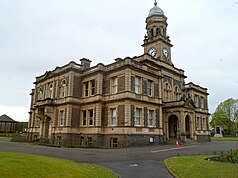
Back ثلانيثلى ARZ سانسی، ولز AZB Ланели Bulgarian Llanelli BR Llanelli (lungsod) CEB Llanelli Czech Llanelli CY Llanelli Danish Llanelli German Llanelli EO
| Llanelli | |
|---|---|
Location within Carmarthenshire | |
| Population | 25,366 (Community, 2021)[1] 42,155 (Built up area, 2021)[2] |
| OS grid reference | SN505005 |
| Community |
|
| Principal area | |
| Preserved county | |
| Country | Wales |
| Sovereign state | United Kingdom |
| Post town | LLANELLI |
| Postcode district | SA14, SA15 |
| Dialling code | 01554[3] |
| Police | Dyfed-Powys |
| Fire | Mid and West Wales |
| Ambulance | Welsh |
| UK Parliament | |
| Senedd Cymru – Welsh Parliament | |
| Website | llanellitowncouncil.co.uk |
Llanelli (Welsh for 'St Elli's Parish'; Welsh: [ɬaˈnɛɬi] ⓘ) is a market town and community in Carmarthenshire and the preserved county of Dyfed, Wales. It is located on the Loughor estuary and is also the largest town in the county of Carmarthenshire.[4]
The town is 11 miles (18 km) north-west of Swansea and 12 miles (19 km) south-east of Carmarthen. At the 2021 census the community had a population of 25,366, and the built up area had a population of 42,155. The local authority was Llanelli Borough Council when the county of Dyfed existed, but it has been under Carmarthenshire County Council since 1996.[5]
- ^ "Llanelli community". City Population. Retrieved 8 January 2025.
- ^ "Towns and cities, characteristics of built-up areas, England and Wales: Census 2021". Census 2021. Office for National Statistics. Retrieved 8 January 2025.
- ^ "Llanelli - UK Codes - The Phone Book from BT". Thephonebook.bt.com. Retrieved 8 February 2016.
- ^ Chisholm, Hugh, ed. (1911). . Encyclopædia Britannica. Vol. 16 (11th ed.). Cambridge University Press. p. 829.
- ^ UK Census (2011). "Local Area Report – Llanelli Parish (W04000519)". Nomis. Office for National Statistics. Retrieved 22 August 2020.


