Back Лонг Айлънд (Бахамски острови) Bulgarian Illa Llarga (Bahames) Catalan Long Island (pulo sa Bahamas, Long Island) CEB Long Island (Bahamy) Czech Long Island (Bahamas) German Λονγκ Άιλαντ (Μπαχάμες) Greek Isla Larga (Bahamas) Spanish جزیره لانگ، باهاما FA Long Island (Bahama) Finnish Long Island (Bahamas) French
District of Long Island | |
|---|---|
 | |
| Coordinates: 23°10′35″N 75°05′46″W / 23.176499°N 75.096212°W | |
| Country | |
| Island | Long Island |
| Established | 1996 |
| Government | |
| • Type | District Council |
| • Chief Councillor | Ian Knowles |
| • Deputy Chief Councillor | Dwayne Fox |
| Area | |
• Total | 596 km2 (230 sq mi) |
| Population (2022) | |
• Total | 2,887[1] |
| Demographics 2010[2] | |
| • Black | 54.36% |
| • Black and White | 20.78% |
| • White | 18.07% |
| • Other | 5.95% |
| Time zone | UTC−5 (EST) |
| • Summer (DST) | UTC−4 (EDT) |
| Area code | 242 |

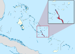
Long Island is an island in The Bahamas that is split by the Tropic of Cancer.[3] It is one of the Districts of the Bahamas and is known as the most scenic island in the Bahamas. Its capital is Clarence Town. The population of Long Island is 3,094 inhabitants.[4]
- ^ "Census population and housing" (PDF). Bahamas Gov. Retrieved 17 April 2023.
- ^ "Department of Statistics of the Bahamas" (PDF). bahamas.gov.bs. Retrieved 30 March 2022.
- ^ Cite error: The named reference
offwas invoked but never defined (see the help page). - ^ LONG ISLAND POPULATION BY SETTLEMENT AND TOTAL NUMBER OF OCCUPIED DWELLINGS: 2010 CENSUS - Bahamas Department of Statistics