Back لونغو ريف (كيبك) Arabic Longue-Rive CEB Longue-Rive (Quebec) EU لونگ-ریو، کبک FA Longue-Rive French Longue-Rive Italian Longue-Rive Swedish
Longue-Rive | |
|---|---|
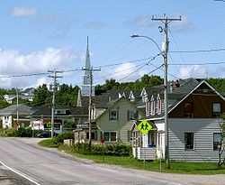
 Rue Principale in Sault-au-Mouton | |
 Location within La Haute-Côte-Nord RCM | |
| Coordinates: 48°33′N 69°15′W / 48.550°N 69.250°W[1] | |
| Country | Canada |
| Province | Quebec |
| Region | Côte-Nord |
| RCM | La Haute-Côte-Nord |
| Constituted | May 28, 1997 |
| Government | |
| • Mayor | Donald Perron |
| • Federal riding | Manicouagan |
| • Prov. riding | René-Lévesque |
| Area | |
• Total | 321.18 km2 (124.01 sq mi) |
| • Land | 308.06 km2 (118.94 sq mi) |
| Population (2021)[3] | |
• Total | 918 |
| • Density | 3.0/km2 (8/sq mi) |
| • Pop (2016-21) | |
| • Dwellings | 562 |
| Time zone | UTC−5 (EST) |
| • Summer (DST) | UTC−4 (EDT) |
| Postal code(s) | |
| Area code(s) | 418 and 581 |
| Highways | |
| Website | longuerive |
Longue-Rive (French pronunciation: [lɔ̃ɡ ʁiv]) is a municipality located on the north shore of the maritime estuary of the St. Lawrence River, in Côte-Nord region, Quebec, Canada.
The municipality includes the communities of Sault-au-Mouton, Baie-des-Bacon, Pointe-à-Boisvert, Rivière-Éperlan and Saint-Paul-du-Nord.
- ^ Cite error: The named reference
toponymiewas invoked but never defined (see the help page). - ^ a b "Longue-Rive (95032)". Répertoire des municipalités. Government of Quebec. 6 May 2024. Retrieved 10 May 2024.
Région administrative Côte-Nord (09) – MRC La Haute-Côte-Nord (950) - Division du recensement-Canada La Haute-Côte-Nord - Circonscription électorale René-Lévesque (906)
- ^ a b "Census Profile, 2021 Census Longue-Rive". Statistics Canada. Retrieved April 14, 2022.
