Back لوكنفالده Arabic لوکنوالده AZB Лукенвальдэ BE Люкенвальдэ BE-X-OLD Луккенвальде CE Luckenwalde (munisipyo) CEB Luckenwalde Danish Luckenwalde German Luckenwalde EO Luckenwalde Spanish
Luckenwalde | |
|---|---|
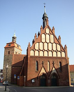
 Market tower and St. John's Church | |
Location of Luckenwalde within Teltow-Fläming district  | |
| Coordinates: 52°05′N 13°10′E / 52.083°N 13.167°E | |
| Country | Germany |
| State | Brandenburg |
| District | Teltow-Fläming |
| Subdivisions | 3 Ortsteile |
| Government | |
| • Mayor (2017–25) | Elisabeth Herzog-von der Heide[1] (SPD) |
| Area | |
• Total | 46.75 km2 (18.05 sq mi) |
| Elevation | 48 m (157 ft) |
| Population (2022-12-31)[2] | |
• Total | 20,839 |
| • Density | 450/km2 (1,200/sq mi) |
| Time zone | UTC+01:00 (CET) |
| • Summer (DST) | UTC+02:00 (CEST) |
| Postal codes | 14943 |
| Dialling codes | 03371 |
| Vehicle registration | TF |
| Website | www.luckenwalde.de |
Luckenwalde (German: [ˌlʊkn̩ˈvaldə] ⓘ; Upper and Lower Sorbian: Łukowc, Upper Sorbian: [ˈwukɔfts], Lower Sorbian: [ˈwukɔwts]) is the capital of the Teltow-Fläming district in the German state of Brandenburg. It is situated on the Nuthe river north of the Fläming Heath, at the eastern rim of the Nuthe-Nieplitz Nature Park, about 50 km (31 mi) south of Berlin. The town area includes the villages of Frankenfelde and Kolzenburg.
- ^ Landkreis Teltow-Fläming Wahl der Bürgermeisterin / des Bürgermeisters, accessed 4 July 2021.
- ^ "Bevölkerungsentwicklung und Bevölkerungsstandim Land Brandenburg Dezember 2022" (PDF). Amt für Statistik Berlin-Brandenburg (in German). June 2023.


