Back Macquarie Harbour German لنگرگاه مکوایر FA Macquarie Harbour French മക്വാരി ഹാർബർ Malayalam Macquarie Harbour Portuguese Маккуори (залив) Russian 麦格理港 Chinese
| Macquarie Harbour | |
|---|---|
| Parralaongatek | |
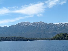
 A view across Macquarie Harbour (Mount Sorell at rear). | |
Location in Tasmania | |
 False colour Landsat image centred on Macquarie Harbour, looking northwest, draped over digital elevation model with x2 vertical exaggeration; screen capture from the NASA World Wind | |
| Location | Western Tasmania |
| Coordinates | 42°17′38″S 145°21′31″E / 42.29389°S 145.35861°E |
| Etymology | Lachlan Macquarie |
| River sources | |
| Ocean/sea sources | Southern Ocean |
| Basin countries | Australia |
| Islands | Sarah Island |
| Sections/sub-basins | |
| Settlements | Strahan |
Macquarie Harbour is a shallow fjord in the West Coast region of Tasmania, Australia. It is approximately 315 square kilometres (122 sq mi), and has an average depth of 15 metres (49 ft), with deeper places up to 50 metres (160 ft). It is navigable by shallow-draft vessels. The main channel is kept clear by the presence of a rock wall on the outside of the channel's curve. This man-made wall prevents erosion and keeps the channel deep and narrow, rather than allowing the channel to become wide and shallow. A reported Aboriginal name for the harbour is Parralaongatek.[1]
The harbour was named in honour of Scottish Major General Lachlan Macquarie, the fifth Colonial Governor of New South Wales.
- ^ Milligan, Joseph (1858). "On the dialects and languages of the Aboriginal Tribes of Tasmania, and on their manners and customs" (PDF). Papers of the Royal Society of Tasmania: 270.
