| Mahoning River | |
|---|---|
 The Mahoning River in Youngstown, Ohio | |
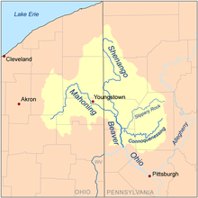
 Map of the Beaver River watershed including the Mahoning River | |
| Location | |
| Country | United States |
| States | Ohio, Pennsylvania |
| Physical characteristics | |
| Source | |
| • location | One half mile southwest of Winona, Ohio |
| • coordinates | 40°49′18″N 80°54′12″W / 40.82167°N 80.90333°W[1] |
| • elevation | 395 m (1,296 ft) above sea level[2] |
| Mouth | Beaver River |
• location | near Mahoningtown, New Castle, Pennsylvania |
• coordinates | 40°57′29″N 80°22′43″W / 40.95806°N 80.37861°W[1] |
• elevation | 232 m (761 ft) above sea level[1] |
| Length | 182 km (113 mi)[3] |
| Basin size | 2,932 km2 (1,132 sq mi) |
| Discharge | |
| • average | 54 m3/s (1,900 cu ft/s)[3] |
The Mahoning River[1] is a river in northeastern Ohio and a small portion of western Pennsylvania. Flowing primarily through several Ohio counties, it crosses the state line into Pennsylvania before joining with the Shenango River to form the Beaver River. The Mahoning River drops from 1,296 feet (395 m)[1] at the headwaters near Winona to 761 feet (232 m)[1] at the outfall near Mahoningtown, Pennsylvania. It is part of the Ohio River watershed. The name is said to derive from either the Lenape or Shawnee languages and mean "Deer Lick," as the area was once known for salt springs,[4] but it's possible the name of the Mahoning and several other similarly named landmarks and places in western Pennsylvania (Manayunk, etc) could come from the Lenape, mënehokink (may-nuh-ho-keeng), meaning "place to get water."[5]
- ^ a b c d e f U.S. Geological Survey Geographic Names Information System: Mahoning River
- ^ Hanoverton, OH, 7.5 Minute Topographic Quadrangle, USGS, 1994 (1997 rev.)
- ^ a b "mahoningriver.com". Archived from the original on 2006-08-21. Retrieved 2006-03-15.
- ^ "Mahoning County". Ohio History Central. Archived from the original on 2022-12-14.
- ^ "Search Results of "Drink" English to Lenape". The Lenape Talking Dictionary.
