Back Glacera de Malaspina Catalan Malaspinagletscher German Glaciar Malaspina Spanish یخچال مالاسپینا FA Malaspinan jäätikkö Finnish Glacier Malaspina French მალასპინა KA Маласпина KY Lodowiec Malaspina Polish Маласпина (ледник) Russian
| Malaspina Glacier | |
|---|---|
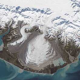
 Malaspina Glacier captured by Landsat 8 on September 24, 2014 | |
| Type | Piedmont |
| Location | Alaska |
| Coordinates | 59°55′09″N 140°31′58″W / 59.91917°N 140.53278°W |
| Area | 3,900 km2 (1,500 sq mi) |
| Length | 45 km (28 mi) |
| Thickness | 600 meters (2,000 ft) |
| Designated | 1969 |
 | |
The Malaspina Glacier (Tlingit: Sít' Tlein) in southeastern Alaska is the largest piedmont glacier in the world. Situated at the head of the Alaska Panhandle, it is about 65 km (40 mi) wide and 45 km (28 mi) long, with an area of some 3,900 km2 (1,500 sq mi),[1] approximately the same size as the state of Rhode Island.
- ^ Scheffel, Richard L.; Wernet, Susan J., eds. (1980). Natural Wonders of the World. United States of America: Reader's Digest Association, Inc. p. 222. ISBN 0-89577-087-3.
