Back Marado AZ Marado CEB Marado Czech Marado Spanish Marado French Մարադո HY 馬羅島 Japanese 마라도 Korean Mara-do NB Mara-do Polish
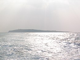
 Marado from a distance | |
 | |
| Geography | |
|---|---|
| Coordinates | 33°07′N 126°16′E / 33.117°N 126.267°E |
| Adjacent to | Korean Strait |
| Area | 0.3 km2 (0.12 sq mi) |
| Coastline | 4.2 km (2.61 mi) |
| Administration | |
| Demographics | |
| Population | 90 |
| Korean name | |
| Hangul | 마라도 |
| Hanja | |
| Revised Romanization | Marado |
| McCune–Reischauer | Marado |

Marado (Korean: 마라도) or Mara Island is an island in Jeju Province, South Korea. It is South Korea's southernmost island, and is 8 km (5.0 mi) off the south coast of Jeju Island.[1][2]
It has an area of 0.3 km2 (0.12 sq mi) and is home to about 90 people. It has long been reputed for having strong women and docile men.[3] In recent years, tourists have come to see its unusual rock formations. It is accessible from Jeju via ferries and excursion boats.
Mara-do is within the administrative boundaries of Daejeong Township (Daejeong-eup) in Seogwipo City, and is included, along with Gapado, in Gapa-ri, and is South Korea's southernmost point.
Because of its subtropical marine habitat the island is a natural reserve. It was designated as National Monument no. 423 (천연기념물 제423호) on July 18, 2000.
- ^ "Introduction to Administrative Units". Korea Land Portal. Archived from the original on 2003-12-08. Retrieved 2007-03-18.
- ^ 韩国 (in Chinese). Yunnan e-government. 2005-04-26. Archived from the original on 2011-09-28.
- ^ Onishi, Norimitsu (July 17, 2006). "A Tourist Boat Nudges Women Out of the Driver's Seat". New York Times. Retrieved May 12, 2010.